Geolocate

Black Cat Ridge topographic map

Click on the map to display elevation.

About this map
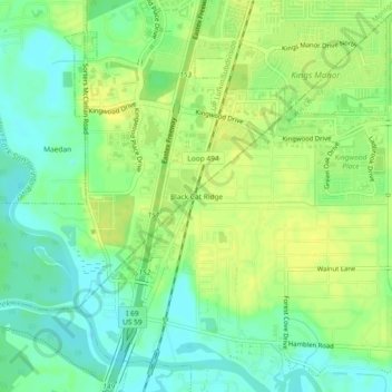
Name: Black Cat Ridge topographic map, elevation, terrain.

Location: Black Cat Ridge, Houston, Harris County, Texas, 77339, United States (30.02362 -95.26957 30.06362 -95.22957)

Average elevation: 79 ft

Minimum elevation: 43 ft

Maximum elevation: 108 ft

Harris County trails, hiking, mountain biking, running and outdoor activities

Other topographic maps

Click on a map to view its topography, its elevation and its terrain.
Yellowstone Park

United States > Texas > Harris County > Houston

Average elevation: 49 ft

Fosters Mill

United States > Texas > Harris County > Houston

Average elevation: 69 ft

Mandell Park

United States > Texas > Harris County > Houston

Average elevation: 59 ft

Brady Island

United States > Texas > Harris County > Houston

Average elevation: 30 ft

Discovery Green

United States > Texas > Harris County > Houston

Average elevation: 52 ft

Cypress Creek

United States > Texas > Harris County > Houston

Average elevation: 115 ft

Memorial Park

United States > Texas > Harris County > Houston

Average elevation: 69 ft

Tuffly Park

United States > Texas > Harris County > Houston

Average elevation: 52 ft

Gear up for your next adventure:

🔦Powerful Headlamps - Ultra-bright hands-free lighting for night navigation
🗻Climbing Gear Basics - Essential gear for beginner climbers
☕Camping Coffee Makers - Enjoy premium coffee at the summit or campsite
🍳Camping Cook Set - Complete cookware for outdoor meals
🦟Ultrasonic Repellers - Create a bug-free zone at your camp or rest stop

As an Amazon Associate, this site earns from qualifying purchases at no extra cost to you.