
Make a donation
Gear up for your next adventure:
As an Amazon Associate, this site earns from qualifying purchases at no extra cost to you.
Glasses Lake topographic map
Click on the map to display elevation.
Make a donation
Gear up for your next adventure:
As an Amazon Associate, this site earns from qualifying purchases at no extra cost to you.
About this map
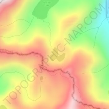
Name: Glasses Lake topographic map, elevation, terrain.
Location: Glasses Lake, Chelan County, Washington, United States (47.84122 -121.13013 47.84475 -121.12434)
Average elevation: 4,491 ft
Minimum elevation: 3,087 ft
Maximum elevation: 5,653 ft
Chelan County trails, hiking, mountain biking, running and outdoor activities
Make a donation
Gear up for your next adventure:
As an Amazon Associate, this site earns from qualifying purchases at no extra cost to you.
Other topographic maps
Click on a map to view its topography, its elevation and its terrain.
Wenatchee Confluence State Park
United States > Washington > Chelan County > Sunnyslope
Average elevation: 682 ft
Colchuck Lake
United States > Washington > Chelan County
Colchuck Lake has an area of approximately 87.8 acres (0.355 km2) and a maximum surface elevation of 5,570 feet above sea level, depending on the fluctuation of the depth of the lake. The lake has a tributary basin of 941 acres (3.81 km2) acres, and an average storage capacity estimated at 1,570 acre-feet.
Average elevation: 6,188 ft
Lake Chelan
United States > Washington > Chelan County > Chelan
Lake Chelan (/ʃəˈlæn/ shə-LAN) is a narrow, 50.5 mi (81.3 km) long lake in Chelan County, north-central Washington state, U.S. It is an overdeepened lake and resembles a fjord, with an average width of 1.3 mi (2.1 km). Near its upper end, the lake surface lies more than 6,600 ft (2,000 m) below peaks less…
Average elevation: 4,455 ft
Make a donation
Gear up for your next adventure:
As an Amazon Associate, this site earns from qualifying purchases at no extra cost to you.
Liberty Bell Mountain
United States > Washington > Chelan County
It is a well-known peak in Washington, although it lacks high prominence and elevation. It is well known for having high-quality alpine climbing, with a short approach since the completion of The Washington Pass Highway. A mixture of high-quality granite and difficult rock has made it a very popular weekend…
Average elevation: 6,017 ft
Leavenworth
United States > Washington > Chelan County > Leavenworth > Leavenworth
Average elevation: 1,982 ft
Make a donation
Gear up for your next adventure:
As an Amazon Associate, this site earns from qualifying purchases at no extra cost to you.
Make a donation
Gear up for your next adventure:
As an Amazon Associate, this site earns from qualifying purchases at no extra cost to you.
Make a donation
Gear up for your next adventure:
As an Amazon Associate, this site earns from qualifying purchases at no extra cost to you.
Make a donation
Gear up for your next adventure:
As an Amazon Associate, this site earns from qualifying purchases at no extra cost to you.