
Sengwa River topographic map
Interactive map
Click on the map to display elevation.
About this map
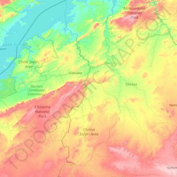
Name: Sengwa River topographic map, elevation, terrain.
Location: Sengwa River, Gokwe North, Midlands, Zimbabwe (-18.30159 28.03112 -16.86604 28.72201)
Average elevation: 2,615 ft
Minimum elevation: 1,575 ft
Maximum elevation: 4,678 ft
Other topographic maps
Click on a map to view its topography, its elevation and its terrain.
Sidakeni Business Center
Zimbabwe > Midlands > Sidakeni Business Center
Sidakeni Business Center, Kwekwe, Midlands, Zimbabwe
Average elevation: 3,360 ft