
Mberengwa topographic map
Interactive map
Click on the map to display elevation.
About this map
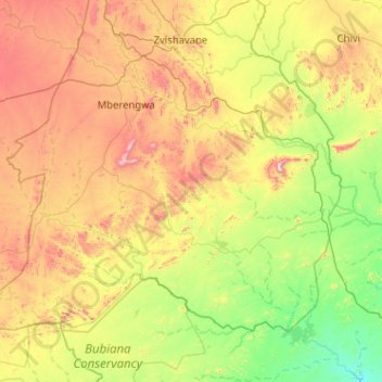
Name: Mberengwa topographic map, elevation, terrain.
Location: Mberengwa, Midlands, Zimbabwe (-21.04735 29.46233 -20.34346 30.48191)
Average elevation: 2,907 ft
Minimum elevation: 1,772 ft
Maximum elevation: 5,210 ft
Other topographic maps
Click on a map to view its topography, its elevation and its terrain.
Sengwa River
Sengwa River, Gokwe North, Midlands, Zimbabwe
Average elevation: 2,615 ft
Sidakeni Business Center
Zimbabwe > Midlands > Sidakeni Business Center
Sidakeni Business Center, Kwekwe, Midlands, Zimbabwe
Average elevation: 3,360 ft