
Bezirk Frauenfeld topographic map
Interactive map
Click on the map to display elevation.
About this map
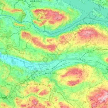
Name: Bezirk Frauenfeld topographic map, elevation, terrain.
Location: Bezirk Frauenfeld, Thurgovie, Suisse (47.50705 8.66797 47.69543 9.04414)
Average elevation: 1,614 ft
Minimum elevation: 1,198 ft
Maximum elevation: 2,556 ft
Other topographic maps
Click on a map to view its topography, its elevation and its terrain.
Gerlikon
Suisse > Thurgovie > Bezirk Frauenfeld > Frauenfeld
Gerlikon, Frauenfeld, Neunforn, Bezirk Frauenfeld, Thurgovie, 8500, Suisse
Average elevation: 1,624 ft
Frauenfeld
Suisse > Thurgovie > Bezirk Frauenfeld
Frauenfeld, Bezirk Frauenfeld, Thurgovie, Suisse
Average elevation: 1,506 ft
Steckborn
Suisse > Thurgovie > Bezirk Frauenfeld
Steckborn, Bezirk Frauenfeld, Thurgovie, 8266, Suisse
Average elevation: 1,677 ft
Romanshorn
Suisse > Thurgovie > Romanshorn
Romanshorn, Bezirk Arbon, Thurgovie, 8590, Suisse
Average elevation: 1,322 ft