
Infantas topographic map
Click on the map to display elevation.
About this map
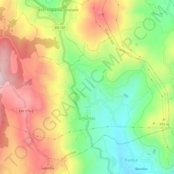
Name: Infantas topographic map, elevation, terrain.
Location: Infantas, Guimarães, Braga, 4810-596, Portugal (41.41500 -8.26546 41.44343 -8.22131)
Average elevation: 1,194 ft
Minimum elevation: 574 ft
Maximum elevation: 1,877 ft
Other topographic maps
Click on a map to view its topography, its elevation and its terrain.
Rio Ave
Portugal > Braga > Guimarães > Gondar
O Ave é um rio português, que nasce na serra da Cabreira, município de Vieira do Minho, a cerca de 1200 m de altitude. Percorre cerca de 91 km e desagua no oceano Atlântico, a sul de Vila do Conde. A sua bacia hidrográfica tem uma área aproximada de 1390 km², abrangendo 15 municípios. O rio banha…
Average elevation: 430 ft
Citânia de Briteiros
O sítio arqueológico da Citânia de Briteiros corresponde a um antigo povoado fortificado de grandes dimensões, com uma área total de cerca de 24 hectares, dos quais apenas cerca de sete hectares fazem parte da zona visitável. Está situado no cume do Monte de São Romão, nas margens do Rio Ave, que no…
Average elevation: 689 ft