Geolocate

Piedmont topographic map

Click on the map to display elevation.

About this map

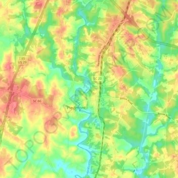
Name: Piedmont topographic map, elevation, terrain.

Location: Piedmont, Anderson County, South Carolina, United States (34.67117 -82.49299 34.74991 -82.43796)

Average elevation: 843 ft

Minimum elevation: 735 ft

Maximum elevation: 951 ft

Anderson County trails, hiking, mountain biking, running and outdoor activities

Other topographic maps

Click on a map to view its topography, its elevation and its terrain.

New Light

United States > South Carolina > Anderson County

Average elevation: 755 ft

Townville

United States > South Carolina > Anderson County

Average elevation: 751 ft

Campbell

United States > South Carolina > Anderson County

Average elevation: 755 ft

Lakefront

United States > South Carolina > Anderson County

Average elevation: 705 ft

Starr

United States > South Carolina > Anderson County

Average elevation: 745 ft

Gear up for your next adventure:

🛰️Handheld GPS Units - Professional satellite navigators for precise backcountry mapping
📷Action Cameras - Rugged cameras to document your journeys across rugged terrain
🧥Men's Rain Shells - Premium waterproof and breathable jackets for mountain weather
🧢Sun Protection Hats - Wide-brimmed and UPF-rated hats for high-altitude sun safety
🦶Hiking Gaiters - Keep debris and water out of your boots

As an Amazon Associate, this site earns from qualifying purchases at no extra cost to you.