
Make a donation
Gear up for your next adventure:
As an Amazon Associate, this site earns from qualifying purchases at no extra cost to you.
Cavite topographic map
Click on the map to display elevation.
Make a donation
Gear up for your next adventure:
As an Amazon Associate, this site earns from qualifying purchases at no extra cost to you.
Cavite
Another theory proposes that the name is a Hispanicized form of kabit, Tagalog for "joined", "connected", or "attached", referring to the peninsula's topographical relation to the mainland. Edmund Roberts, in his 1821 memoir, stated that the "natives" called it Caveit due to the "crooked point of land extending into the sea".
Make a donation
Gear up for your next adventure:
As an Amazon Associate, this site earns from qualifying purchases at no extra cost to you.
About this map
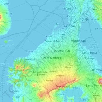
Name: Cavite topographic map, elevation, terrain.
Location: Cavite, Calabarzon, Philippines (14.05687 120.41614 14.58564 121.07768)
Average elevation: 289 ft
Minimum elevation: -7 ft
Maximum elevation: 3,478 ft
Make a donation
Gear up for your next adventure:
As an Amazon Associate, this site earns from qualifying purchases at no extra cost to you.
Other topographic maps
Click on a map to view its topography, its elevation and its terrain.
Quezon City
Founded as a pueblo by Saint Pedro Bautista in 1590, San Francisco del Monte may be considered Quezon City's oldest district. The original land area of the old town of San Francisco del Monte was approximately2.5 square kilometres (1.0 sq mi) and covered parts of what is currently known as Project 7 and 8 and…
Average elevation: 187 ft
Baguio
In 1903, Filipinos, Japanese and Chinese workers were hired to build Kennon Road, the first road directly connecting Baguio with the lowlands of La Union and Pangasinan. Before this, the only road to Benguet was Naguilian Road, and it was largely a horse trail at higher elevations. Camp John Hay was…
Average elevation: 2,890 ft
Make a donation
Gear up for your next adventure:
As an Amazon Associate, this site earns from qualifying purchases at no extra cost to you.
Naguilian
The approximate elevation of the municipality is 165 meters above sea level. It has the ninth highest approximate average elevation among the twenty (20) towns of the province. The portion with the highest elevation is 544 meters above sea level while the lowest is 10 meters. The slopes range from 2–7% in…
Average elevation: 279 ft
Make a donation
Gear up for your next adventure:
As an Amazon Associate, this site earns from qualifying purchases at no extra cost to you.
Make a donation
Gear up for your next adventure:
As an Amazon Associate, this site earns from qualifying purchases at no extra cost to you.
Make a donation
Gear up for your next adventure:
As an Amazon Associate, this site earns from qualifying purchases at no extra cost to you.
Make a donation
Gear up for your next adventure:
As an Amazon Associate, this site earns from qualifying purchases at no extra cost to you.
General Tinio
Farming is the livelihood of majority of the residents. Even though located at the foot of the Sierra Madre Mountain Ridges, the topography is generally plain ideal to agricultural products such as palay and vegetables. A number of poultry broiler contract growers are located in the municipality. Other…
Average elevation: 177 ft
Make a donation
Gear up for your next adventure:
As an Amazon Associate, this site earns from qualifying purchases at no extra cost to you.
Valenzuela
The highest elevation point is 38 meters (125 ft) above sea level. Having a surface gradient of 0.55% and a gentle slope, hilly landscape is located in the industrial section of the city in Canumay. The average elevation point is 2 meters (6.6 ft) above sea level.
Average elevation: 79 ft
Make a donation
Gear up for your next adventure:
As an Amazon Associate, this site earns from qualifying purchases at no extra cost to you.
Mandaluyong
Another claims that the Spaniards named the place based on the report of a navigator named Acapulco, who saw the rolling hills frequently being lashed at by daluyong (“big waves from the sea”). This seems to confirm traditional pre-Hispanic stories that giant waves from the sea would meet the adjoining…
Average elevation: 108 ft
Make a donation
Gear up for your next adventure:
As an Amazon Associate, this site earns from qualifying purchases at no extra cost to you.
Mount Halcon
Philippines > Oriental Mindoro
Mount Halcon (Filipino: Bundok Halcon) and (Spanish: Monte Halcón) is the highest mountain in Mindoro. According to the new data released by Oriental Mindoro peakvisor as of 2022, it has an elevation of 2,616 metres (8,583 ft) above sea level, higher than the previous estimates of 2,586 m (8,484 ft) although…
Average elevation: 6,959 ft
Mount Isarog
Philippines > Camarines Sur > Consocep
Mount Isarog is an active stratovolcano located in the province of Camarines Sur, Philippines, on the island of Luzon. The mountain has active fumaroles and hot springs. It has an elevation of 2,011.6 m (6,600 ft) above mean sea level.
Average elevation: 2,201 ft
Make a donation
Gear up for your next adventure:
As an Amazon Associate, this site earns from qualifying purchases at no extra cost to you.
Legazpi
Legazpi's topography is generally plain on the northeastern areas, with slopes ranging from five to fifteen degrees. The southern areas have mostly rolling to hilly terrain. In the city's coastal areas, the terrain varies from plain (north) to hilly (south). Legazpi is criss-crossed by several rivers including…
Average elevation: 492 ft
Trece Martires
The city of Trece Martires is characterised with ground elevation ranging from 30m to nearly 400m. Its ground slope ranges from 0.5 to 2%.
Average elevation: 492 ft
Make a donation
Gear up for your next adventure:
As an Amazon Associate, this site earns from qualifying purchases at no extra cost to you.
Tagaytay
The southern and eastern portions of Tagaytay are covered by hills and mountains which is generally forests, pine trees and open grasslands. The city lies along Tagaytay Ridge, a ridge stretching about 32 kilometres (20 mi) from Mount Batulao in the west to Mount Sungay in the east with elevations averaging…
Average elevation: 751 ft
Make a donation
Gear up for your next adventure:
As an Amazon Associate, this site earns from qualifying purchases at no extra cost to you.
San Juan
"San Juan" is a contraction of the city's traditional name of "San Juan del Monte" (lit. 'Saint John of the Mountain'). As with numerous other places in the Philippines, the name combines a patron saint and a toponym; in this case Saint John the Baptist with the locale's hilly terrain and relatively higher…
Average elevation: 115 ft
Make a donation
Gear up for your next adventure:
As an Amazon Associate, this site earns from qualifying purchases at no extra cost to you.
Make a donation
Gear up for your next adventure:
As an Amazon Associate, this site earns from qualifying purchases at no extra cost to you.
Make a donation
Gear up for your next adventure:
As an Amazon Associate, this site earns from qualifying purchases at no extra cost to you.
Make a donation
Gear up for your next adventure:
As an Amazon Associate, this site earns from qualifying purchases at no extra cost to you.
Buhi
Buhi has generally mountainous and hilly surface, with 50% of its area having a slope of around 25%. The Poblacion located on the south shore of Lake Buhi, has gently rolling topography.
Average elevation: 528 ft
Make a donation
Gear up for your next adventure:
As an Amazon Associate, this site earns from qualifying purchases at no extra cost to you.
Make a donation
Gear up for your next adventure:
As an Amazon Associate, this site earns from qualifying purchases at no extra cost to you.
Indang
Philippines > Cavite > Indang
The topography of Indang is characterised by gently sloping or rolling terrain. Almost 40.36% of its total land area is within the slope grade of 3-8%, while 2,135 hectares is within the slope range of 8-15% which is characterised by undulating or sloping terrain.
Average elevation: 978 ft
Make a donation
Gear up for your next adventure:
As an Amazon Associate, this site earns from qualifying purchases at no extra cost to you.
Make a donation
Gear up for your next adventure:
As an Amazon Associate, this site earns from qualifying purchases at no extra cost to you.
Balamban
Farming is another source of livelihood for residents with corn, crops and vegetables among the important crops. The municipality is also the only source of abaca fibers in Cebu produced in a 260-to-300-hectare (640-to-740-acre) plantation in Mount Manunggal in barangay Magsaysay. With the elevation of 500…
Average elevation: 92 ft
Make a donation
Gear up for your next adventure:
As an Amazon Associate, this site earns from qualifying purchases at no extra cost to you.
Make a donation
Gear up for your next adventure:
As an Amazon Associate, this site earns from qualifying purchases at no extra cost to you.
Make a donation
Gear up for your next adventure:
As an Amazon Associate, this site earns from qualifying purchases at no extra cost to you.
Make a donation
Gear up for your next adventure:
As an Amazon Associate, this site earns from qualifying purchases at no extra cost to you.
Make a donation
Gear up for your next adventure:
As an Amazon Associate, this site earns from qualifying purchases at no extra cost to you.
Make a donation
Gear up for your next adventure:
As an Amazon Associate, this site earns from qualifying purchases at no extra cost to you.