Geolocate

Vegadeo topographic map

Click on the map to display elevation.

About this map
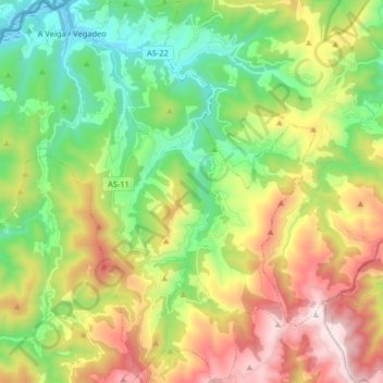
Name: Vegadeo topographic map, elevation, terrain.

Location: Vegadeo, Asturias, Spain (43.35654 -7.10635 43.47436 -6.94690)

Average elevation: 1,490 ft

Minimum elevation: -10 ft

Maximum elevation: 3,871 ft

Other topographic maps

Click on a map to view its topography, its elevation and its terrain.
El Ferrol

Spain > Asturias > Castropol

Average elevation: 128 ft

Avín

Spain > Asturias > Onís > Benia de Onís

Average elevation: 1,289 ft

Boriñes

Spain > Asturias > Piloña

Average elevation: 1,017 ft

Chagos

Spain > Asturias > Cangas del Narcea > Ḷḷarón > La Vilieḷḷa

Average elevation: 3,143 ft

Liares

Spain > Asturias > Ibias

Average elevation: 2,339 ft

El Retornu

Spain > Asturias > Piloña

Average elevation: 1,942 ft

Sotrondio

Spain > Asturias > Samartín del Rei Aurelio

Average elevation: 1,391 ft

La Barganiza

Spain > Asturias > Siero

Average elevation: 653 ft

Siecha

Spain > Asturias > Cangas del Narcea

Average elevation: 2,927 ft

Gear up for your next adventure:

🧦Merino Wool Socks - Moisture-wicking, blister-preventing socks for long treks
🧢Sun Protection Hats - Wide-brimmed and UPF-rated hats for high-altitude sun safety
📚Navigation Handbooks - Master the art of reading topographic maps and using a compass
🛌Ultralight Sleeping Bags - Compact down bags for cold nights in the wilderness
🪶Multi‑Purpose Knife - Useful blade for camp and trail

As an Amazon Associate, this site earns from qualifying purchases at no extra cost to you.