Eagle Mountain topographic map
Click on the map to display elevation.
About this map

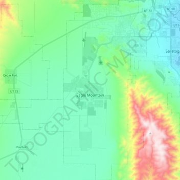
Name: Eagle Mountain topographic map, elevation, terrain.
Location: Eagle Mountain, Utah County, Utah, 84005, United States (40.23225 -112.13010 40.39496 -111.94501)
Average elevation: 5,213 ft
Minimum elevation: 4,482 ft
Maximum elevation: 7,674 ft
Eagle Mountain's climate varies drastically between the northeastern Ranches area and the southwestern City Center area. Despite being further south than Salt Lake City, both areas have cooler temperatures due to sitting at a higher elevation. The Ranches section of the city has slightly milder temperatures since it is closer to the moderating impact of the Salt Lake and Utah Valleys as well as the Great Salt Lake, which gives it a climate more similar to Salt Lake City. The City Center area near Fairfield lies in the Cedar Valley, which cuts that area off from the moderating influence of the Salt Lake Valley and Great Salt lake. This causes nights to get significantly colder than in the Ranches but also puts it in a rain shadow causing less precipitation and more sunshine than the Ranches part of the city.
Other topographic maps
Click on a map to view its topography, its elevation and its terrain.

Lehi
United States > Utah > Utah County
Lehi, Utah County, Utah, 84043, United States
Average elevation: 4,806 ft

Utah Lake
United States > Utah > Utah County
Utah Lake, Utah County, Utah, United States
Average elevation: 4,961 ft

Orem
United States > Utah > Utah County
Orem, Utah County, Utah, United States
Average elevation: 4,783 ft

Townsend
United States > Utah > Utah County > Genola
Townsend, Genola, Utah County, Utah, 84655, United States
Average elevation: 4,718 ft

Provo
United States > Utah > Utah County
Provo, Utah County, Utah, United States
Average elevation: 5,669 ft

Fairfield
United States > Utah > Utah County
Fairfield, Utah County, Utah, United States
Average elevation: 5,013 ft

Santaquin
United States > Utah > Utah County
Santaquin, Utah County, Utah, 84655, United States
Average elevation: 5,394 ft

Olmsted
United States > Utah > Utah County > Orem
Olmsted, Orem, Utah County, Utah, 84604, United States
Average elevation: 5,230 ft

Pleasant Grove
United States > Utah > Utah County
Pleasant Grove, Utah County, Utah, 84062, United States
Average elevation: 5,279 ft

Saratoga Springs
United States > Utah > Utah County
Saratoga Springs, Utah County, Utah, 84045, United States
Average elevation: 4,905 ft

Elk Ridge
United States > Utah > Utah County
Elk Ridge, Utah County, Utah, United States
Average elevation: 5,571 ft

Vineyard
United States > Utah > Utah County
Vineyard, Utah County, Utah, 84059, United States
Average elevation: 4,534 ft

Mapleton
United States > Utah > Utah County
Mapleton, Utah County, Utah, 84664, United States
Average elevation: 5,518 ft

Edgemont
United States > Utah > Utah County > Provo
Edgemont, Provo, Utah County, Utah, 84604, United States
Average elevation: 5,046 ft

Alpine
United States > Utah > Utah County
Alpine, Utah County, Utah, 84004, United States
Average elevation: 5,459 ft

Deer Creek
United States > Utah > Utah County
Deer Creek, Utah County, Utah, United States
Average elevation: 6,991 ft