
Mount Timpanogos topographic map
Click on the map to display elevation.
About this map
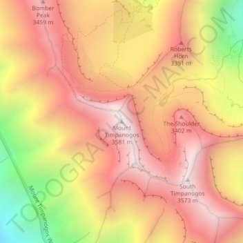
Name: Mount Timpanogos topographic map, elevation, terrain.
Location: Mount Timpanogos, Utah County, Utah, United States (40.39078 -111.64611 40.39088 -111.64601)
Average elevation: 10,299 ft
Minimum elevation: 7,913 ft
Maximum elevation: 11,722 ft
Utah County trails, hiking, mountain biking, running and outdoor activities
Other topographic maps
Click on a map to view its topography, its elevation and its terrain.
Orem
United States > Utah > Utah County
Orem is located at 40°17′56″N 111°41′47″W / 40.29889°N 111.69639°W / 40.29889; -111.69639 (40.298753, -111.696486). Situated in a high desert, with an average elevation of 4,756 feet. According to the United States Census Bureau, the city has a total area of 18.4 square miles (48 km2), all…
Average elevation: 4,783 ft
Saratoga Springs
United States > Utah > Utah County
Saratoga Springs is a city in Utah County, Utah, United States. The elevation is 4,505 feet. It is part of the Provo–Orem, Utah Metropolitan Statistical Area. The city is a relatively new development along the northwestern shores of Utah Lake. It was incorporated on December 31, 1997 and has been growing…
Average elevation: 4,905 ft
Provo
United States > Utah > Utah County
Provo lies in the Utah Valley at an elevation of 4,549 feet (1,387 m). According to the United States Census Bureau, the city has an area of 44.2 square miles (114.4 km2), of which 41.7 square miles (107.9 km2) is land and 2.5 square miles (6.5 km2), or 5.66%, is water.
Average elevation: 5,669 ft
Eagle Mountain
United States > Utah > Utah County
Eagle Mountain's climate varies drastically between the northeastern Ranches area and the southwestern City Center area. Despite being further south than Salt Lake City, both areas have cooler temperatures due to sitting at a higher elevation. The Ranches section of the city has slightly milder temperatures…
Average elevation: 5,213 ft
Mapleton
United States > Utah > Utah County
According to the United States Census Bureau, the city has a total area of 12.6 square miles (32.6 km2), all land. The community lies at an elevation of 4,700 feet (1,400 m) above sea level.
Average elevation: 5,518 ft
American Fork
United States > Utah > Utah County
The elevation is 4,566 feet (1,392 m) above sea level.
Average elevation: 4,610 ft
Provo
United States > Utah > Utah County
Provo lies in the Utah Valley at an elevation of 4,549 feet (1,387 m). According to the United States Census Bureau, the city has an area of 44.2 square miles (114.4 km2), of which 41.7 square miles (107.9 km2) is land and 2.5 square miles (6.5 km2), or 5.66%, is water.
Average elevation: 5,669 ft
Orem
United States > Utah > Utah County
Orem is in a high desert, with an average elevation of 4,767 ft (1,453 m). According to the United States Census Bureau, the city covers an area of 18.4 sq mi (48 km2), all land. Orem is near the eastern shore of Utah Lake, bordering Provo on the east and south, Vineyard to the west, Lindon contiguous to the…
Average elevation: 4,783 ft
Provo
United States > Utah > Utah County
Provo lies on the eastern bank of Utah Lake in Utah Valley at an elevation of 4,549 feet (1,387 m). According to the United States Census Bureau, the city has an area of 44.2 square miles (114.4 km2), of which 41.7 square miles (107.9 km2) is land and 2.5 square miles (6.5 km2), or 5.66%, is water.
Average elevation: 5,669 ft
Eagle Mountain
United States > Utah > Utah County
Eagle Mountain's climate varies drastically between the northeastern Ranches area and the southwestern City Center area. Despite being further south than Salt Lake City, both areas have cooler temperatures due to sitting at a higher elevation. The Ranches section of the city has slightly milder temperatures…
Average elevation: 5,213 ft
Provo
United States > Utah > Utah County
Provo lies on the eastern bank of Utah Lake in Utah Valley at an elevation of 4,549 feet (1,387 m). According to the United States Census Bureau, the city has an area of 44.2 square miles (114.4 km2), of which 41.7 square miles (107.9 km2) is land and 2.5 square miles (6.5 km2), or 5.66%, is water.
Average elevation: 5,669 ft
American Fork
United States > Utah > Utah County
Elevations throughout the city range from 4,566 feet (1,392 m) to 4,619 feet (1,408 m) above sea level.
Average elevation: 4,610 ft
Saratoga Springs
United States > Utah > Utah County
Saratoga Springs is a city in Utah County, Utah, United States. The elevation is 4,505 feet. It is part of the Provo–Orem, Utah Metropolitan Statistical Area. The city is a relatively new development along the northwestern shores of Utah Lake. It was incorporated on December 31, 1997 and has been growing…
Average elevation: 4,921 ft
Provo
United States > Utah > Utah County
Provo lies on the eastern bank of Utah Lake in Utah Valley at an elevation of 4,549 feet (1,387 m). According to the United States Census Bureau, the city has an area of 44.2 square miles (114.4 km2), of which 41.7 square miles (107.9 km2) is land and 2.5 square miles (6.5 km2), or 5.66%, is water.
Average elevation: 5,669 ft
Mapleton
United States > Utah > Utah County
According to the United States Census Bureau, the city has a total area of 12.6 square miles (32.6 km2), all land. The community lies at an elevation of 4,700 feet (1,400 m) above sea level.
Average elevation: 5,518 ft
Mapleton
United States > Utah > Utah County
According to the United States Census Bureau, the city has a total area of 12.6 square miles (32.6 km2), all land. The community lies at an elevation of 4,700 feet (1,400 m) above sea level.
Average elevation: 5,518 ft
Provo
United States > Utah > Utah County
Provo lies on the eastern bank of Utah Lake in Utah Valley at an elevation of 4,549 feet (1,387 m). According to the United States Census Bureau, the city has an area of 44.2 square miles (114.4 km2), of which 41.7 square miles (107.9 km2) is land and 2.5 square miles (6.5 km2), or 5.66%, is water.
Average elevation: 5,669 ft