
Make a donation
Gear up for your next adventure:
As an Amazon Associate, this site earns from qualifying purchases at no extra cost to you.
Municipio Sucre topographic map
Click on the map to display elevation.
Make a donation
Gear up for your next adventure:
As an Amazon Associate, this site earns from qualifying purchases at no extra cost to you.
About this map
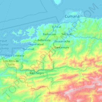
Name: Municipio Sucre topographic map, elevation, terrain.
Location: Municipio Sucre, Estado Sucre, Venezuela (10.06061 -64.53159 10.48853 -64.01029)
Average elevation: 1,562 ft
Minimum elevation: -3 ft
Maximum elevation: 7,920 ft
Make a donation
Gear up for your next adventure:
As an Amazon Associate, this site earns from qualifying purchases at no extra cost to you.
Other topographic maps
Click on a map to view its topography, its elevation and its terrain.
Make a donation
Gear up for your next adventure:
As an Amazon Associate, this site earns from qualifying purchases at no extra cost to you.
Península de Araya
Venezuela > Estado Sucre > Municipio Cruz Salmerón Acosta
Average elevation: 486 ft
Make a donation
Gear up for your next adventure:
As an Amazon Associate, this site earns from qualifying purchases at no extra cost to you.
Plaza José Féllix Rivas
Venezuela > Estado Sucre > Municipio Bermúdez > Carúpano
Average elevation: 92 ft
Make a donation
Gear up for your next adventure:
As an Amazon Associate, this site earns from qualifying purchases at no extra cost to you.
Make a donation
Gear up for your next adventure:
As an Amazon Associate, this site earns from qualifying purchases at no extra cost to you.
Make a donation
Gear up for your next adventure:
As an Amazon Associate, this site earns from qualifying purchases at no extra cost to you.
Cañón del Colorado
Venezuela > Estado Sucre > Municipio Sucre > San Pedrito
Average elevation: 1,316 ft
Make a donation
Gear up for your next adventure:
As an Amazon Associate, this site earns from qualifying purchases at no extra cost to you.
Make a donation
Gear up for your next adventure:
As an Amazon Associate, this site earns from qualifying purchases at no extra cost to you.
Make a donation
Gear up for your next adventure:
As an Amazon Associate, this site earns from qualifying purchases at no extra cost to you.
Punta del Burro
Venezuela > Estado Sucre > Municipio Cruz Salmerón Acosta > Punta Angoleta
Average elevation: 43 ft