Geolocate

Beckett topographic map

Click on the map to display elevation.

About this map

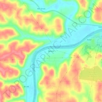
Name: Beckett topographic map, elevation, terrain.

Location: Beckett, Washington County, Ohio, United States (39.56452 -81.72791 39.60452 -81.68791)

Average elevation: 764 ft

Minimum elevation: 614 ft

Maximum elevation: 932 ft

Other topographic maps

Click on a map to view its topography, its elevation and its terrain.

Marietta

United States > Ohio > Washington County

Average elevation: 705 ft

Belpre

United States > Ohio > Washington County

Average elevation: 676 ft

Lowell

United States > Ohio > Washington County

Average elevation: 728 ft

Duck Creek

United States > Ohio > Washington County > Marietta

Average elevation: 794 ft

Beverly

United States > Ohio > Washington County

Average elevation: 705 ft

Duck Creek

United States > Ohio > Washington County > Marietta

Average elevation: 794 ft

Marietta

United States > Ohio > Washington County

Average elevation: 705 ft

Gear up for your next adventure:

🎒Hydration Pack - Hands‑free water reservoir for long hikes
🪑Portable Camp Table - Compact table for campsite meals
👟Trail Running Shoes - Lightweight shoes for trail runners
🥄Camping Utensil Set - Lightweight utensils for outdoor meals
🪶Multi‑Purpose Knife - Useful blade for camp and trail

As an Amazon Associate, this site earns from qualifying purchases at no extra cost to you.