Geolocate

Beverly topographic map

Click on the map to display elevation.

About this map

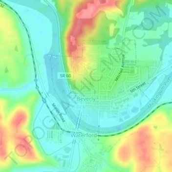
Name: Beverly topographic map, elevation, terrain.

Location: Beverly, Washington County, Ohio, United States (39.54270 -81.64673 39.55720 -81.62584)

Average elevation: 705 ft

Minimum elevation: 600 ft

Maximum elevation: 909 ft

Other topographic maps

Click on a map to view its topography, its elevation and its terrain.

Barlow

United States > Ohio > Washington County

Average elevation: 794 ft

Layman

United States > Ohio > Washington County

Average elevation: 856 ft

Reno

United States > Ohio > Washington County

Average elevation: 686 ft

Little Hocking

United States > Ohio > Washington County

Average elevation: 663 ft

Little Hocking

United States > Ohio > Washington County

Average elevation: 663 ft

Constitution

United States > Ohio > Washington County

Average elevation: 709 ft

Beckett

United States > Ohio > Washington County

Average elevation: 764 ft

Gear up for your next adventure:

Solar GPS Watches - Advanced multisport watches with built-in topographic maps
🩳Quick‑Dry Hiking Shorts - Comfortable and quick‑dry shorts for summer hiking
🔭Compact Binoculars - HD vision for scouting terrain and identifying distant landmarks
🌧️Backpack Rain Cover - Keep gear dry in wet weather
🔦Compact Flashlight - Reliable flashlight for emergencies

As an Amazon Associate, this site earns from qualifying purchases at no extra cost to you.