Geolocate

Marietta topographic map

Click on the map to display elevation.

About this map

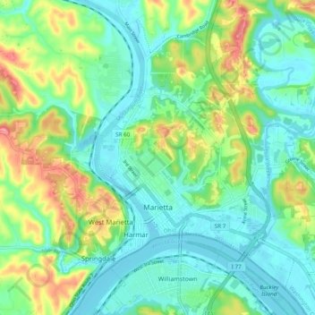
Name: Marietta topographic map, elevation, terrain.

Location: Marietta, Washington County, Ohio, 45750, United States (39.39764 -81.49748 39.45923 -81.40193)

Average elevation: 705 ft

Minimum elevation: 591 ft

Maximum elevation: 971 ft

Washington County trails, hiking, mountain biking, running and outdoor activities

Other topographic maps

Click on a map to view its topography, its elevation and its terrain.

Layman

United States > Ohio > Washington County

Average elevation: 856 ft

Barlow

United States > Ohio > Washington County

Average elevation: 794 ft

Little Hocking

United States > Ohio > Washington County

Average elevation: 663 ft

Little Hocking

United States > Ohio > Washington County

Average elevation: 663 ft

Constitution

United States > Ohio > Washington County

Average elevation: 709 ft

Beckett

United States > Ohio > Washington County

Average elevation: 764 ft

Gear up for your next adventure:

🪑Portable Camp Table - Compact table for campsite meals
🌡️Handheld Weather Meters - Measure wind, temp, and pressure for safe mountain travel
🥘Titanium Cookware - Durable, featherlight pots and pans for backpacking
🌲Outdoor Survival Books - Best books on survival skills
🧺Microfiber Travel Towels - Compact and fast-drying towels for trail use

As an Amazon Associate, this site earns from qualifying purchases at no extra cost to you.