
Lake Mead topographic map
Click on the map to display elevation.
Lake Mead
At maximum capacity, Lake Mead is 112 miles (180 km) long, 532 feet (162 m) at its greatest depth, has a surface elevation of 1,221.4 feet (372.3 m) above sea level and 247 square miles (640 km2) of surface area, and contains 26.12 million acre feet (3.222×10¹³ L) of water.
About this map
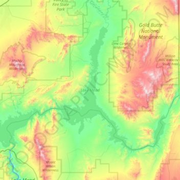
Name: Lake Mead topographic map, elevation, terrain.
Location: Lake Mead, Clark County, Nevada, United States (36.00097 -114.83948 36.43337 -114.09881)
Average elevation: 2,244 ft
Minimum elevation: 659 ft
Maximum elevation: 5,663 ft
Clark County trails, hiking, mountain biking, running and outdoor activities
Other topographic maps
Click on a map to view its topography, its elevation and its terrain.
Carey–Lake Mead Detention Basin
United States > Nevada > Clark County > North Las Vegas
Average elevation: 2,126 ft
Boulder City
United States > Nevada > Clark County > Boulder City > Boulder City
Average elevation: 1,939 ft