
Make a donation
Gear up for your next adventure:
As an Amazon Associate, this site earns from qualifying purchases at no extra cost to you.
Saddleback Rock topographic map
Click on the map to display elevation.
Make a donation
Gear up for your next adventure:
As an Amazon Associate, this site earns from qualifying purchases at no extra cost to you.
About this map
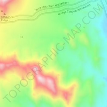
Name: Saddleback Rock topographic map, elevation, terrain.
Location: Saddleback Rock, Clark County, Nevada, United States (35.24870 -114.69988 35.24880 -114.69978)
Average elevation: 3,143 ft
Minimum elevation: 2,598 ft
Maximum elevation: 3,914 ft
Clark County trails, hiking, mountain biking, running and outdoor activities
Make a donation
Gear up for your next adventure:
As an Amazon Associate, this site earns from qualifying purchases at no extra cost to you.
Other topographic maps
Click on a map to view its topography, its elevation and its terrain.
Make a donation
Gear up for your next adventure:
As an Amazon Associate, this site earns from qualifying purchases at no extra cost to you.
Lake Mead
United States > Nevada > Clark County
At maximum capacity, Lake Mead is 112 miles (180 km) long, 532 feet (162 m) at its greatest depth, has a surface elevation of 1,221.4 feet (372.3 m) above sea level and 247 square miles (640 km2) of surface area, and contains 26.12 million acre feet (3.222×10¹³ L) of water.
Average elevation: 2,244 ft
Make a donation
Gear up for your next adventure:
As an Amazon Associate, this site earns from qualifying purchases at no extra cost to you.
Carey–Lake Mead Detention Basin
United States > Nevada > Clark County > North Las Vegas
Average elevation: 2,126 ft
Make a donation
Gear up for your next adventure:
As an Amazon Associate, this site earns from qualifying purchases at no extra cost to you.