
Make a donation
Gear up for your next adventure:
As an Amazon Associate, this site earns from qualifying purchases at no extra cost to you.
Mijares topographic map
Click on the map to display elevation.
Make a donation
Gear up for your next adventure:
As an Amazon Associate, this site earns from qualifying purchases at no extra cost to you.
About this map
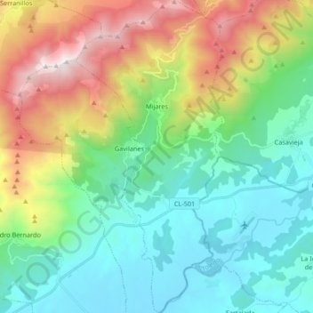
Name: Mijares topographic map, elevation, terrain.
Location: Mijares, Ávila, Castile and León, 05461, Spain (40.21250 -4.87977 40.33800 -4.80260)
Average elevation: 3,058 ft
Minimum elevation: 1,302 ft
Maximum elevation: 7,152 ft
Make a donation
Gear up for your next adventure:
As an Amazon Associate, this site earns from qualifying purchases at no extra cost to you.
Other topographic maps
Click on a map to view its topography, its elevation and its terrain.
Make a donation
Gear up for your next adventure:
As an Amazon Associate, this site earns from qualifying purchases at no extra cost to you.
Presa Vieja de Las Navas del Marques
Spain > Castile and León > Peguerinos
Average elevation: 4,908 ft
Make a donation
Gear up for your next adventure:
As an Amazon Associate, this site earns from qualifying purchases at no extra cost to you.