
Make a donation
Gear up for your next adventure:
As an Amazon Associate, this site earns from qualifying purchases at no extra cost to you.
Raquette Lake topographic map
Click on the map to display elevation.
Make a donation
Gear up for your next adventure:
As an Amazon Associate, this site earns from qualifying purchases at no extra cost to you.
About this map
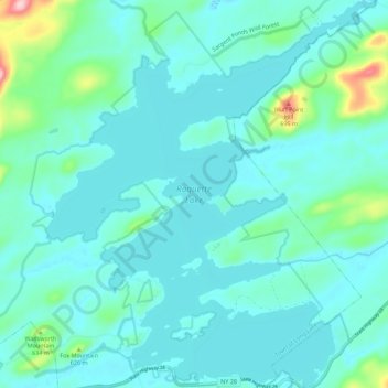
Name: Raquette Lake topographic map, elevation, terrain.
Average elevation: 1,834 ft
Minimum elevation: 1,736 ft
Maximum elevation: 2,411 ft
Hamilton County trails, hiking, mountain biking, running and outdoor activities
Make a donation
Gear up for your next adventure:
As an Amazon Associate, this site earns from qualifying purchases at no extra cost to you.
Other topographic maps
Click on a map to view its topography, its elevation and its terrain.
Cedar River
United States > New York > Hamilton County > Town of Lake Pleasant
Average elevation: 2,503 ft
Sagamore Lake
United States > New York > Hamilton County > Town of Long Lake > Sagamore
Average elevation: 2,008 ft
Make a donation
Gear up for your next adventure:
As an Amazon Associate, this site earns from qualifying purchases at no extra cost to you.
Grampus Lake
United States > New York > Hamilton County > Town of Long Lake
Average elevation: 1,860 ft
Make a donation
Gear up for your next adventure:
As an Amazon Associate, this site earns from qualifying purchases at no extra cost to you.
Eagle Lake
United States > New York > Hamilton County > Town of Indian Lake > Eagle Nest
Average elevation: 1,890 ft
Make a donation
Gear up for your next adventure:
As an Amazon Associate, this site earns from qualifying purchases at no extra cost to you.
Make a donation
Gear up for your next adventure:
As an Amazon Associate, this site earns from qualifying purchases at no extra cost to you.
Three Ponds Mountain
United States > New York > Hamilton County > Town of Benson
Average elevation: 2,425 ft