
Make a donation
Gear up for your next adventure:
As an Amazon Associate, this site earns from qualifying purchases at no extra cost to you.
Tbilisi topographic map
Click on the map to display elevation.
Make a donation
Gear up for your next adventure:
As an Amazon Associate, this site earns from qualifying purchases at no extra cost to you.
Tbilisi
Most of the raions are named after historic quarters of the city. The citizens of Tbilisi widely recognise an informal system of smaller historic neighbourhoods. Such neighbourhoods are several, however, constituting a kind of hierarchy, because most of them have lost their distinctive topographic limits. The natural first level of subdivision of the city is into the Right Bank and the Left Bank of the Mt'k'vari.
Make a donation
Gear up for your next adventure:
As an Amazon Associate, this site earns from qualifying purchases at no extra cost to you.
About this map
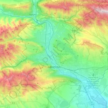
Name: Tbilisi topographic map, elevation, terrain.
Location: Tbilisi, Georgia (41.61779 44.59620 41.84388 45.01729)
Average elevation: 2,480 ft
Minimum elevation: 1,083 ft
Maximum elevation: 5,620 ft
Make a donation
Gear up for your next adventure:
As an Amazon Associate, this site earns from qualifying purchases at no extra cost to you.
Other topographic maps
Click on a map to view its topography, its elevation and its terrain.
Caucasus Mountains
Georgia > Mtskheta-Mtianeti > Dusheti Municipality > Chalisopeli
The climate of the Caucasus varies both vertically (according to elevation) and horizontally (by latitude and location). Temperature generally decreases as elevation rises. Average annual temperature in Sukhumi, Abkhazia at sea level is 15 °C (59 °F) while on the slopes of Mt.Kazbek at an elevation of 3,700…
Average elevation: 7,178 ft
Paledi
Georgia > Samegrelo-Upper Svaneti > Mestia Municipality > Gheshderi
Average elevation: 5,364 ft
Very steep, dangerous route
Georgia > Samegrelo-Upper Svaneti > Mestia Municipality
Average elevation: 6,152 ft
Make a donation
Gear up for your next adventure:
As an Amazon Associate, this site earns from qualifying purchases at no extra cost to you.
Kveda Tkhilvana
Georgia > Autonomous Republic of Adjara > Khulo Municipality
Average elevation: 5,364 ft
Make a donation
Gear up for your next adventure:
As an Amazon Associate, this site earns from qualifying purchases at no extra cost to you.
Jvari
Georgia > Samegrelo-Upper Svaneti > Tsalenjikha Municipality
Jvari (Georgian: ჯვარი) is a town in the northwestern Georgian province of Samegrelo-Zemo Svaneti. The town is situated at an altitude of 280 metres near the Magana River where it flows into the Enguri River; The town is divided in two with "Jvari" lying on the Zugdidi-Mestia highway, and Jvarzeni…
Average elevation: 1,476 ft
Make a donation
Gear up for your next adventure:
As an Amazon Associate, this site earns from qualifying purchases at no extra cost to you.
Bakuriani
Georgia > Samtskhe-Javakheti > Borjomi Municipality
Bakuriani (Georgian: ბაკურიანი) is a daba and a ski resort in the Borjomi district of Georgia. It is located on the northern slope of the Trialeti Range, at an elevation of 1,700 meters (5,576 feet) above sea level.
Average elevation: 5,761 ft
Make a donation
Gear up for your next adventure:
As an Amazon Associate, this site earns from qualifying purchases at no extra cost to you.
Make a donation
Gear up for your next adventure:
As an Amazon Associate, this site earns from qualifying purchases at no extra cost to you.
Chitagvalashi
Georgia > Samegrelo-Upper Svaneti > Chkhorotsqu Municipality
Average elevation: 8,757 ft
Kveda Sairme
Georgia > Racha-Lechkhumi and Kvemo Svaneti > Tsageri Municipality
Average elevation: 2,195 ft
Make a donation
Gear up for your next adventure:
As an Amazon Associate, this site earns from qualifying purchases at no extra cost to you.
Make a donation
Gear up for your next adventure:
As an Amazon Associate, this site earns from qualifying purchases at no extra cost to you.
Saghamo Lake
Georgia > Samtskhe-Javakheti > Ninotsminda Municipality > Saghamo
Average elevation: 6,637 ft
Make a donation
Gear up for your next adventure:
As an Amazon Associate, this site earns from qualifying purchases at no extra cost to you.
Mestia
Georgia > Samegrelo-Upper Svaneti > Mestia Municipality
Mestia (Georgian: მესტია IPA: [mestʼia]) is a highland townlet (daba) in northwest Georgia, at an elevation of 1,500 metres (4,921 feet) in the Caucasus Mountains.
Average elevation: 5,778 ft
Make a donation
Gear up for your next adventure:
As an Amazon Associate, this site earns from qualifying purchases at no extra cost to you.
Mtkvari
Georgia > Shida Kartli > Khashuri Municipality > Rbona
Most of the Kura runs in the broad and deep valley between the Greater Caucasus and Lesser Caucasus Mountains, and the major tributary, the Aras, drains most of the southern Caucasus and the mountain ranges of the extreme northern Middle East. The entirety of Armenia and most of Azerbaijan are drained by the…
Average elevation: 2,562 ft
Senaki
Georgia > Samegrelo-Upper Svaneti > Senaki Municipality
Senaki (Georgian: სენაკი, senak'i; Mingrelian: სანაკი, sanak'i) is a city in Samegrelo-Zemo Svaneti region, western Georgia. It is located at around 42°16′8″N 42°4′45″E / 42.26889°N 42.07917°E / 42.26889; 42.07917 between the rivers Tekhura/i and Tsivi, at an…
Average elevation: 262 ft
Caucasus Mountains
Georgia > Mtskheta-Mtianeti > Dusheti Municipality > Chalisopeli
The climate of the Caucasus varies both vertically (according to elevation) and horizontally (by latitude and location). Temperature generally decreases as elevation rises. Average annual temperature in Sokhumi, Abkhazia at sea level is 15 °C (59 °F) while on the slopes of Mt.Kazbek at an elevation of 3,700…
Average elevation: 7,178 ft
Make a donation
Gear up for your next adventure:
As an Amazon Associate, this site earns from qualifying purchases at no extra cost to you.
Mestia
Georgia > Samegrelo-Upper Svaneti > Mestia Municipality
Mestia (Georgian: მესტია IPA: [mestʼia]) is a highland townlet (daba) in northwest Georgia, at an elevation of 1,500 metres (4,921 feet) in the Caucasus Mountains.
Average elevation: 5,778 ft
Mtirala
Georgia > Autonomous Republic of Adjara > Khelvachauri Municipality
Average elevation: 3,281 ft
Vardzia
Georgia > Samtskhe-Javakheti > Aspindza Municipality
The greater Vardzia area includes fifteen churches. The most significant, apart from the Church of Dormition, are also the early eleventh-century church at Zeda Vardzia and the tenth- to twelfth-century rock village and cave churches of Ananauri. The latter contains original frescos. The main lower site was…
Average elevation: 5,105 ft
Make a donation
Gear up for your next adventure:
As an Amazon Associate, this site earns from qualifying purchases at no extra cost to you.
Lomanauri
Georgia > Autonomous Republic of Adjara > Shuakhevi Municipality
Average elevation: 3,560 ft
Make a donation
Gear up for your next adventure:
As an Amazon Associate, this site earns from qualifying purchases at no extra cost to you.
Gachedili
Georgia > Samegrelo-Upper Svaneti > Martvili Municipality
Gachedili (Georgian: გაჭედილი; Mingrelian: გოჭკადილი) is a village located in the Martvili Municipality of the Samegrelo-Zemo Svaneti region in Georgia. Gachedili is situated on the right bank of the Abasha river. At an altitude of 240 meters, it is 8 kilometers to Martvili…
Average elevation: 1,161 ft
Make a donation
Gear up for your next adventure:
As an Amazon Associate, this site earns from qualifying purchases at no extra cost to you.
Green Lake
Georgia > Racha-Lechkhumi and Kvemo Svaneti > Tsageri Municipality
Average elevation: 3,737 ft
Make a donation
Gear up for your next adventure:
As an Amazon Associate, this site earns from qualifying purchases at no extra cost to you.
Make a donation
Gear up for your next adventure:
As an Amazon Associate, this site earns from qualifying purchases at no extra cost to you.
Make a donation
Gear up for your next adventure:
As an Amazon Associate, this site earns from qualifying purchases at no extra cost to you.
Make a donation
Gear up for your next adventure:
As an Amazon Associate, this site earns from qualifying purchases at no extra cost to you.
Make a donation
Gear up for your next adventure:
As an Amazon Associate, this site earns from qualifying purchases at no extra cost to you.
Shan
Georgia > Mtskheta-Mtianeti > Kazbegi Municipality
Mt. Shani (Ingush: Шанлоам, lit. ''icy mountain''; Georgian: შანი; Russian: Шан) also known as Shan and Shanloam is a mountain in the Caucasus. It has an elevation of 4,451 metres (14,603 ft) and is on the international border between Georgia and Ingushetia, Russia.
Average elevation: 11,877 ft
Lentekhi
Georgia > Racha-Lechkhumi and Kvemo Svaneti > Lentekhi Municipality
Average elevation: 3,110 ft
Make a donation
Gear up for your next adventure:
As an Amazon Associate, this site earns from qualifying purchases at no extra cost to you.
Tbilisa Glacier
Georgia > Racha-Lechkhumi and Kvemo Svaneti > Oni Municipality
Average elevation: 11,296 ft
Make a donation
Gear up for your next adventure:
As an Amazon Associate, this site earns from qualifying purchases at no extra cost to you.
Mirveti
Georgia > Autonomous Republic of Adjara > Khelvachauri Municipality
Average elevation: 1,030 ft
Make a donation
Gear up for your next adventure:
As an Amazon Associate, this site earns from qualifying purchases at no extra cost to you.
Mirveti
Georgia > Autonomous Republic of Adjara > Khelvachauri Municipality
Average elevation: 1,030 ft
Makhuntseti waterfall
Georgia > Autonomous Republic of Adjara > Keda Municipality > Zeda Makhuntseti
Average elevation: 1,161 ft
Make a donation
Gear up for your next adventure:
As an Amazon Associate, this site earns from qualifying purchases at no extra cost to you.
Mirveti Waterfall
Georgia > Autonomous Republic of Adjara > Khelvachauri Municipality > Mirveti
Average elevation: 974 ft
Make a donation
Gear up for your next adventure:
As an Amazon Associate, this site earns from qualifying purchases at no extra cost to you.
Shemokmedi
Georgia > Guria > Ozurgeti Municipality
Shemokmedi (Georgian: შემოქმედი) is a village in the Ozurgeti Municipality, Guria, Georgia. It is located in western Georgia, on the Bzhuzhi river, at elevation of 190 m above sea level, 7 km east of the city of Ozurgeti. The village is home to the late medieval Shemokmedi Monastery.
Average elevation: 594 ft
Cold Waterfall
Georgia > Autonomous Republic of Adjara > Khelvachauri Municipality > Sarpi
Average elevation: 331 ft
Merisi waterfall
Georgia > Autonomous Republic of Adjara > Keda Municipality > Gundauri
Average elevation: 2,959 ft
Make a donation
Gear up for your next adventure:
As an Amazon Associate, this site earns from qualifying purchases at no extra cost to you.
Nokalakevi (Tsikhegoji)
Georgia > Samegrelo-Upper Svaneti > Senaki Municipality > Gakhomela
Average elevation: 518 ft
Shemokmedi
Georgia > Guria > Ozurgeti Municipality
Shemokmedi (Georgian: შემოქმედი) is a village in the Ozurgeti Municipality, Guria, Georgia. It is located in western Georgia, on the Bzhuzhi river, at elevation of 190 m above sea level, 7 km east of the city of Ozurgeti. The village is home to the late medieval Shemokmedi Monastery.
Average elevation: 594 ft
Make a donation
Gear up for your next adventure:
As an Amazon Associate, this site earns from qualifying purchases at no extra cost to you.