
Make a donation
Gear up for your next adventure:
As an Amazon Associate, this site earns from qualifying purchases at no extra cost to you.
Andover topographic map
Click on the map to display elevation.
Make a donation
Gear up for your next adventure:
As an Amazon Associate, this site earns from qualifying purchases at no extra cost to you.
Andover
Ragged Mountain, elevation 2,286 feet (697 m) above sea level, is on the northern boundary. The northern slopes of Mount Kearsarge occupy the southernmost part of town and contain the town's highest point, 2,460 ft (750 m) above sea level.
Make a donation
Gear up for your next adventure:
As an Amazon Associate, this site earns from qualifying purchases at no extra cost to you.
About this map
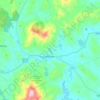
Name: Andover topographic map, elevation, terrain.
Location: Andover, Merrimack County, New Hampshire, United States (43.38902 -71.89415 43.50311 -71.69556)
Average elevation: 988 ft
Minimum elevation: 535 ft
Maximum elevation: 2,907 ft
Merrimack County trails, hiking, mountain biking, running and outdoor activities
Make a donation
Gear up for your next adventure:
As an Amazon Associate, this site earns from qualifying purchases at no extra cost to you.
Other topographic maps
Click on a map to view its topography, its elevation and its terrain.
Catamount Mountain
United States > New Hampshire > Merrimack County > Pittsfield
Average elevation: 922 ft
Make a donation
Gear up for your next adventure:
As an Amazon Associate, this site earns from qualifying purchases at no extra cost to you.
Make a donation
Gear up for your next adventure:
As an Amazon Associate, this site earns from qualifying purchases at no extra cost to you.
Shaker Village
United States > New Hampshire > Merrimack County > Canterbury
Average elevation: 673 ft
Make a donation
Gear up for your next adventure:
As an Amazon Associate, this site earns from qualifying purchases at no extra cost to you.
Rings Corner
United States > New Hampshire > Merrimack County > Pittsfield > Rings Corner
Average elevation: 623 ft
Make a donation
Gear up for your next adventure:
As an Amazon Associate, this site earns from qualifying purchases at no extra cost to you.