Geolocate

Everton topographic map

Click on the map to display elevation.

About this map

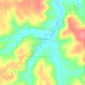
Name: Everton topographic map, elevation, terrain.

Location: Everton, Boone County, Arkansas, 72633, United States (36.14959 -92.91705 36.15884 -92.90260)

Average elevation: 958 ft

Minimum elevation: 830 ft

Maximum elevation: 1,112 ft

Boone County trails, hiking, mountain biking, running and outdoor activities

Other topographic maps

Click on a map to view its topography, its elevation and its terrain.

Batavia

United States > Arkansas > Boone County

Average elevation: 1,493 ft

Capps

United States > Arkansas > Boone County

Average elevation: 1,424 ft

Olvey

United States > Arkansas > Boone County

Average elevation: 1,109 ft

Little Arkansaw

United States > Arkansas > Boone County

Average elevation: 1,427 ft

Lead Hill

United States > Arkansas > Boone County

Average elevation: 1,004 ft

Gear up for your next adventure:

🚪Portable Camp Chair - Foldable chair for comfort at camp
🧯Portable Fire Pit - Compact fire pit for camping spots
🎒Gear Packing Cubes - Organize your backpack efficiently
🥾Hiking Shoes - Durable and comfortable shoes for trail hiking
🧯Emergency Survival Kit - All‑in‑one survival essentials for the backcountry

As an Amazon Associate, this site earns from qualifying purchases at no extra cost to you.