Geolocate

Watts topographic map

Click on the map to display elevation.

About this map

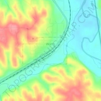
Name: Watts topographic map, elevation, terrain.

Location: Watts, Adair County, Oklahoma, United States (36.10388 -94.57944 36.11107 -94.56480)

Average elevation: 1,030 ft

Minimum elevation: 902 ft

Maximum elevation: 1,201 ft

Adair County trails, hiking, mountain biking, running and outdoor activities

Other topographic maps

Click on a map to view its topography, its elevation and its terrain.

Baron

United States > Oklahoma > Adair County

Average elevation: 971 ft

Bunch

United States > Oklahoma > Adair County

Average elevation: 935 ft

Gear up for your next adventure:

📖Nature Tracking Books - Learn to track wildlife and terrain
🧭Orienteering Set - Complete compass and map reading kit
🦺Reflective Outdoor Gear - Safety gear for low‑light conditions
🪶Camping Sleeping Pad - Comfortable sleeping pad for backpacking
🗺️NatGeo Topo Maps - High-quality waterproof printed topographic maps of US Parks

As an Amazon Associate, this site earns from qualifying purchases at no extra cost to you.