Geolocate

Baron topographic map

Click on the map to display elevation.

About this map

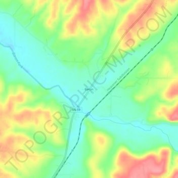
Name: Baron topographic map, elevation, terrain.

Location: Baron, Adair County, Oklahoma, United States (35.90370 -94.63633 35.94370 -94.59633)

Average elevation: 971 ft

Minimum elevation: 846 ft

Maximum elevation: 1,142 ft

Adair County trails, hiking, mountain biking, running and outdoor activities

Other topographic maps

Click on a map to view its topography, its elevation and its terrain.

Bell

United States > Oklahoma > Adair County

Average elevation: 1,240 ft

Watts

United States > Oklahoma > Adair County

Average elevation: 1,030 ft

Westville

United States > Oklahoma > Adair County

Average elevation: 1,138 ft

Stilwell

United States > Oklahoma > Adair County

Average elevation: 1,155 ft

Gear up for your next adventure:

🪵Folding Camp Saw - Compact saw for wood and campsite work
🏕️Tent Footprint - Protect your tent base from wear
🦺Reflective Outdoor Gear - Safety gear for low‑light conditions
🧭Hiking Compass - Precision compass for reliable navigation in the wilderness
📷Action Camera - Capture your outdoor adventures in HD

As an Amazon Associate, this site earns from qualifying purchases at no extra cost to you.