
Make a donation
Gear up for your next adventure:
As an Amazon Associate, this site earns from qualifying purchases at no extra cost to you.
Lübeck topographic map
Click on the map to display elevation.
Make a donation
Gear up for your next adventure:
As an Amazon Associate, this site earns from qualifying purchases at no extra cost to you.
About this map
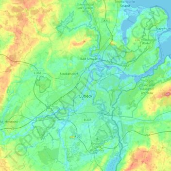
Name: Lübeck topographic map, elevation, terrain.
Location: Lübeck, Schleswig-Holstein, Germany (53.76801 10.55404 53.99389 10.96863)
Average elevation: 82 ft
Minimum elevation: -13 ft
Maximum elevation: 358 ft
Make a donation
Gear up for your next adventure:
As an Amazon Associate, this site earns from qualifying purchases at no extra cost to you.
Other topographic maps
Click on a map to view its topography, its elevation and its terrain.
Ludwigsburg
Germany > Schleswig-Holstein > Kreis Rendsburg-Eckernförde > Waabs
Average elevation: 56 ft
Make a donation
Gear up for your next adventure:
As an Amazon Associate, this site earns from qualifying purchases at no extra cost to you.
Pelzerhaken
Germany > Schleswig-Holstein > Kreis Ostholstein > Neustadt in Holstein
Average elevation: 26 ft
Make a donation
Gear up for your next adventure:
As an Amazon Associate, this site earns from qualifying purchases at no extra cost to you.
Make a donation
Gear up for your next adventure:
As an Amazon Associate, this site earns from qualifying purchases at no extra cost to you.
Alter Meldorfer Hafen
Germany > Schleswig-Holstein > Kreis Dithmarschen > Meldorf
Average elevation: 7 ft
Make a donation
Gear up for your next adventure:
As an Amazon Associate, this site earns from qualifying purchases at no extra cost to you.
Pelzerhaken
Germany > Schleswig-Holstein > Ostholstein > Neustadt in Holstein
Average elevation: 26 ft
Make a donation
Gear up for your next adventure:
As an Amazon Associate, this site earns from qualifying purchases at no extra cost to you.
Strand Seekamp
Germany > Schleswig-Holstein > Kreis Segeberg > Berlin > Seekamp
Average elevation: 125 ft
Make a donation
Gear up for your next adventure:
As an Amazon Associate, this site earns from qualifying purchases at no extra cost to you.
Make a donation
Gear up for your next adventure:
As an Amazon Associate, this site earns from qualifying purchases at no extra cost to you.
Make a donation
Gear up for your next adventure:
As an Amazon Associate, this site earns from qualifying purchases at no extra cost to you.
Schleswig
Germany > Schleswig-Holstein > Schleswig-Flensburg > Schleswig > Schleswig
Average elevation: 79 ft
Make a donation
Gear up for your next adventure:
As an Amazon Associate, this site earns from qualifying purchases at no extra cost to you.