Geolocate

Pinneberg topographic map

Click on the map to display elevation.

About this map

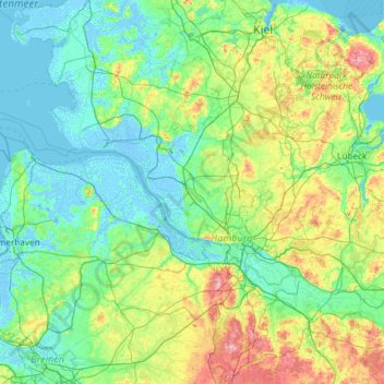
Name: Pinneberg topographic map, elevation, terrain.

Location: Pinneberg, Schleswig-Holstein, 25337, Germany (53.02789 8.99796 54.42789 10.39796)

Average elevation: 75 ft

Minimum elevation: -20 ft

Maximum elevation: 515 ft

Other topographic maps

Click on a map to view its topography, its elevation and its terrain.

Kiel Canal

Germany > Schleswig-Holstein

Average elevation: 49 ft

Bargteheide

Germany > Schleswig-Holstein > Kreis Stormarn

Average elevation: 138 ft

25719

Germany > Schleswig-Holstein > Kreis Dithmarschen > Barlt

Average elevation: 3 ft

Hüxwiese

Germany > Schleswig-Holstein > Lübeck

Average elevation: 36 ft

Heilshoop

Germany > Schleswig-Holstein > Kreis Stormarn

Average elevation: 92 ft

Glinde

Germany > Schleswig-Holstein > Kreis Stormarn

Average elevation: 108 ft

Sylt

Germany > Schleswig-Holstein > Northern Friesland

The island's shape has constantly shifted over time, a process which is still ongoing today. The northern and southern spits of Sylt are exclusively made up of infertile sand deposits, while the central part with the municipalities of Westerland, Wenningstedt-Braderup and Sylt-Ost consists of a geestland core,…

Average elevation: 0 ft

Bark

Germany > Schleswig-Holstein > Kreis Segeberg

Average elevation: 135 ft

Kiel

Germany > Schleswig-Holstein

Average elevation: 72 ft

Dune

Germany > Schleswig-Holstein > Kreis Pinneberg > Helgoland

Average elevation: 0 ft

Quickborn

Germany > Schleswig-Holstein > Kreis Pinneberg

Average elevation: 75 ft

Borstel-Hohenraden

Germany > Schleswig-Holstein > Kreis Pinneberg

On the origin and meaning of the name: "Tho the Borstelde" in "Kerspell Rellinghen" clearly indicate our Borstel. Over the centuries, the name of Borstelde over Borstele, Borstell, Borsteler altered, Barstell to Borstel (the Urdorf). Originally, the name comes from the Old Saxon "bur" = home and "Stal" =…

Average elevation: 39 ft

Quickborn

Germany > Schleswig-Holstein > Dithmarschen

Average elevation: 66 ft

Meddewade

Germany > Schleswig-Holstein > Stormarn

Average elevation: 98 ft

Dithmarschen

Germany > Schleswig-Holstein

Average elevation: 16 ft

Holm

Germany > Schleswig-Holstein > Northern Friesland

Average elevation: 10 ft

Bilsen

Germany > Schleswig-Holstein > Kreis Pinneberg

Average elevation: 72 ft

Oldendorf

Germany > Schleswig-Holstein > Kreis Steinburg

Average elevation: 33 ft

24149

Germany > Schleswig-Holstein > Kiel

Average elevation: 59 ft

23867

Germany > Schleswig-Holstein > Kreis Segeberg > Sülfeld

Average elevation: 118 ft

Sylt

Germany > Schleswig-Holstein > Northern Friesland

The island's shape has constantly shifted over time, a process which is still ongoing today. The northern and southern spits of Sylt are exclusively made up of infertile sand deposits, while the central part with the municipalities of Westerland, Wenningstedt-Braderup and Sylt-Ost consists of a geestland core,…

Average elevation: 0 ft

23701

Germany > Schleswig-Holstein > Eutin

Average elevation: 151 ft

Wahlstedt

Germany > Schleswig-Holstein > Kreis Segeberg

Average elevation: 144 ft

Oering

Germany > Schleswig-Holstein > Kreis Segeberg

Average elevation: 108 ft

Selent

Germany > Schleswig-Holstein > Plön

Average elevation: 177 ft

Looft

Germany > Schleswig-Holstein > Kreis Steinburg

Average elevation: 66 ft

Itzehoe

Germany > Schleswig-Holstein > Kreis Steinburg

Average elevation: 62 ft

Kollow

Germany > Schleswig-Holstein > Herzogtum Lauenburg

Average elevation: 157 ft

Kiel

Germany > Schleswig-Holstein

Average elevation: 72 ft

Friedhof

Germany > Schleswig-Holstein > Flensburg

Average elevation: 138 ft

Exe

Germany > Schleswig-Holstein > Flensburg

Average elevation: 118 ft

Bunsoh

Germany > Schleswig-Holstein > Kreis Dithmarschen

Average elevation: 82 ft

24105

Germany > Schleswig-Holstein > Kiel

Average elevation: 52 ft

Selent

Germany > Schleswig-Holstein > Kreis Plön

Average elevation: 177 ft

Sylt

Germany > Schleswig-Holstein > Northern Friesland

The island's shape has constantly shifted over time, a process which is still ongoing today. The northern and southern spits of Sylt are exclusively made up of infertile sand deposits, while the central part with the municipalities of Westerland, Wenningstedt-Braderup and Sylt-Ost consists of a geestland core,…

Average elevation: 0 ft

Tasdorf

Germany > Schleswig-Holstein > Kreis Plön

Average elevation: 95 ft

Moorrege

Germany > Schleswig-Holstein > Kreis Pinneberg

Average elevation: 20 ft

Marne

Germany > Schleswig-Holstein > Kreis Dithmarschen

Average elevation: 3 ft

Plön

Germany > Schleswig-Holstein > Kreis Plön

Average elevation: 112 ft

Selent

Germany > Schleswig-Holstein > Kreis Plön

Average elevation: 177 ft

Husum

Germany > Schleswig-Holstein > Northern Friesland

Average elevation: 26 ft

Lübeck

Germany > Schleswig-Holstein

Average elevation: 82 ft

Lübeck

Germany > Schleswig-Holstein

Average elevation: 82 ft

Malente

Germany > Schleswig-Holstein > Ostholstein

Average elevation: 138 ft

Plön

Germany > Schleswig-Holstein

Average elevation: 108 ft

Gear up for your next adventure:

🌧️Backpack Rain Cover - Keep gear dry in wet weather
🥾Men's Hiking Boots - Durable, waterproof footwear for rugged terrain and steep inclines
⛑️Personal Locator Beacon - Safety beacon for emergencies
👟Trail Running Shoes - Lightweight shoes for trail runners
Solar GPS Watches - Advanced multisport watches with built-in topographic maps

As an Amazon Associate, this site earns from qualifying purchases at no extra cost to you.