Geolocate

Raichur topographic map

Click on the map to display elevation.

About this map

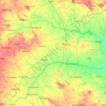
Name: Raichur topographic map, elevation, terrain.

Location: Raichur, Raichur District, Karnataka, India (15.38333 76.46667 16.78333 77.86667)

Average elevation: 1,316 ft

Minimum elevation: 892 ft

Maximum elevation: 2,287 ft

Other topographic maps

Click on a map to view its topography, its elevation and its terrain.

Nelamangala taluk

India > Karnataka

Average elevation: 2,913 ft

Kolar Gold Field taluk

India > Karnataka

Average elevation: 2,608 ft

Mysuru taluk

India > Karnataka

Average elevation: 2,372 ft

Anagalapura

India > Karnataka > Bangalore East > Anagalapura

Average elevation: 2,917 ft

Maragondanahalli

India > Karnataka > Nelamangala taluk > Kasaraghatta

Average elevation: 3,012 ft

Sonnappanahalli

India > Karnataka > Yelahanka taluku > Vidyanagar

Average elevation: 3,018 ft

Bangalore East

India > Karnataka

Average elevation: 2,917 ft

Yelahanka Lake

India > Karnataka > Yelahanka taluku > Bengaluru

Average elevation: 2,966 ft

Thanisandra

India > Karnataka > Bangalore East > Bengaluru

Average elevation: 2,930 ft

Sampangiram Nagar Ward

India > Karnataka > Bangalore North > Bengaluru

Average elevation: 3,009 ft

Koramangala

India > Karnataka > Bangalore South > Bengaluru

Average elevation: 2,933 ft

BTM

India > Karnataka > Bangalore South > Bengaluru

Average elevation: 2,949 ft

Anekal

India > Karnataka

Average elevation: 2,913 ft

Ullal Lake

India > Karnataka > Bangalore North > Bengaluru

Average elevation: 2,766 ft

Dakshina Kannada

India > Karnataka

The topography of the district is plain up to 30 km (18.64 mi) inside the coast and changes to undulating hilly terrain sharply towards the east in the Western Ghats. Teak, bamboo and rosewood trees are found in the hilly areas towards the east. The Geological Survey of India has identified this district as a…

Average elevation: 358 ft

Devanahalli taluk

India > Karnataka

Average elevation: 2,976 ft

Kaneri

India > Karnataka > Supa taluk

Average elevation: 1,703 ft

Uttarahalli

India > Karnataka > Bangalore South > Bengaluru

Average elevation: 2,864 ft

Mundargi taluku

India > Karnataka

Average elevation: 1,919 ft

Sedam taluku

India > Karnataka > Sedam taluku

Average elevation: 1,617 ft

HBR Layout

India > Karnataka > Bangalore North > Bengaluru

Average elevation: 2,930 ft

Rainbow Drive Park

India > Karnataka > Bangalore East > Bengaluru

Average elevation: 2,920 ft

Kammanahalli

India > Karnataka > Bangalore North > Bengaluru

Average elevation: 2,979 ft

Kundapura

India > Karnataka > Kundapura

Average elevation: 712 ft

Saul Kere

India > Karnataka > Bangalore East > Bengaluru

Average elevation: 2,900 ft

Kasavanahalli Lake

India > Karnataka > Bangalore South > Bengaluru

Average elevation: 2,936 ft

Vidyaranyapura

India > Karnataka > Bangalore North > Bengaluru

Average elevation: 3,018 ft

Gokak taluku

India > Karnataka

Average elevation: 2,093 ft

Gear up for your next adventure:

🔦LED Headlamp - Bright and durable LED headlamp for night navigation
🦶Carbon Trekking Poles - Reduce knee impact on steep descents with ultra-light poles
🔌Solar Panel Charger - Charge gear sustainably outdoors
🧤Tactile Hiking Gloves - Keep hands warm while operating GPS and smartphone screens
🪶Multi‑Purpose Knife - Useful blade for camp and trail

As an Amazon Associate, this site earns from qualifying purchases at no extra cost to you.