Geolocate

Beaver topographic map

Click on the map to display elevation.

About this map

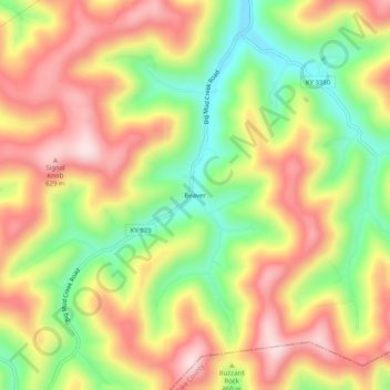
Name: Beaver topographic map, elevation, terrain.

Location: Beaver, Floyd County, Kentucky, 41660, United States (37.37677 -82.67432 37.41677 -82.63432)

Average elevation: 1,453 ft

Minimum elevation: 866 ft

Maximum elevation: 2,001 ft

Floyd County trails, hiking, mountain biking, running and outdoor activities

Other topographic maps

Click on a map to view its topography, its elevation and its terrain.

Wheelwright

United States > Kentucky > Floyd County

Average elevation: 1,460 ft

Allen

United States > Kentucky > Floyd County

Average elevation: 856 ft

Martin

United States > Kentucky > Floyd County

Average elevation: 883 ft

Gear up for your next adventure:

☀️Outdoor Sunscreen - High protection sunscreen for outdoor activities
🪑Portable Camp Table - Compact table for campsite meals
🛠️Outdoor Gear Repair Kit - Essential tools to fix gear on the trail
📶Vehicle Signal Boosters - Improve reception in rural areas while driving to trailheads
💧Water Filtration Bottles - Safely drink from streams and lakes while exploring

As an Amazon Associate, this site earns from qualifying purchases at no extra cost to you.