Geolocate

Jackson Lake topographic map

Click on the map to display elevation.

About this map

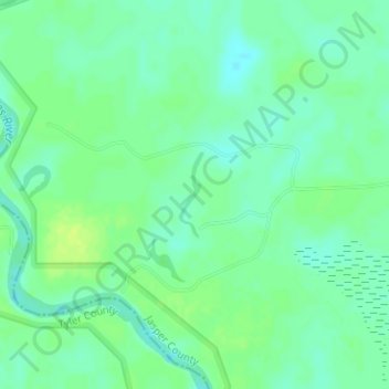
Name: Jackson Lake topographic map, elevation, terrain.

Location: Jackson Lake, Jasper County, Texas, United States (30.55156 -94.07297 30.55753 -94.07097)

Average elevation: 59 ft

Minimum elevation: 36 ft

Maximum elevation: 85 ft

Jasper County trails, hiking, mountain biking, running and outdoor activities

Other topographic maps

Click on a map to view its topography, its elevation and its terrain.

Spring Hill

United States > Texas > Jasper County

Average elevation: 197 ft

Sam Rayburn

United States > Texas > Jasper County

Average elevation: 217 ft

Evadale

United States > Texas > Jasper County

Average elevation: 43 ft

Call Junction

United States > Texas > Jasper County > Call Junction

Average elevation: 105 ft

Kirbyville

United States > Texas > Jasper County

Average elevation: 108 ft

Gear up for your next adventure:

🩹Survival Bandages - High‑quality bandages for emergencies
🌡️Portable Weather Meter - Track weather conditions on the trail
🎒Gear Packing Cubes - Organize your backpack efficiently
📷Action Cameras - Rugged cameras to document your journeys across rugged terrain
💧Water Filtration Bottles - Safely drink from streams and lakes while exploring

As an Amazon Associate, this site earns from qualifying purchases at no extra cost to you.