Geolocate

Chandler topographic map

Click on the map to display elevation.

About this map

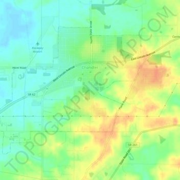
Name: Chandler topographic map, elevation, terrain.

Location: Chandler, Warrick County, Indiana, 47610, United States (38.02204 -87.40187 38.05106 -87.35019)

Average elevation: 423 ft

Minimum elevation: 367 ft

Maximum elevation: 492 ft

Warrick County trails, hiking, mountain biking, running and outdoor activities

Other topographic maps

Click on a map to view its topography, its elevation and its terrain.

Yankeetown

United States > Indiana > Warrick County

Average elevation: 417 ft

Newburgh

United States > Indiana > Warrick County > Newburgh

Average elevation: 394 ft

Saint John

United States > Indiana > Warrick County

Average elevation: 407 ft

Gear up for your next adventure:

🪶Camping Sleeping Pad - Comfortable sleeping pad for backpacking
🧯Portable Fire Pit - Compact fire pit for camping spots
😴Insulated Sleeping Pads - Compact and warm pads for high-elevation camping
🪑Ultralight Camp Chairs - Portable seating for resting after a long day of mapping
🧣Merino Neck Gaiters - Multi-functional headwear for wind and sun protection

As an Amazon Associate, this site earns from qualifying purchases at no extra cost to you.