
Woleu-Ntem topographic map
Interactive map
Click on the map to display elevation.
About this map
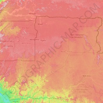
Name: Woleu-Ntem topographic map, elevation, terrain.
Location: Woleu-Ntem, Gabon (0.22360 10.28541 2.31929 13.30560)
Average elevation: 1,732 ft
Minimum elevation: 69 ft
Maximum elevation: 3,543 ft
Other topographic maps
Click on a map to view its topography, its elevation and its terrain.
Cap Lopez
Gabon > Ogooué-Maritime Province > Port-Gentil
Cap Lopez, Port-Gentil, Ogooué-Maritime Province, Gabon
Average elevation: 3 ft
Port-Gentil
Gabon > Ogooué-Maritime Province
Port-Gentil, Ogooué-Maritime Province, Gabon
Average elevation: 3 ft
Romboe
Gabon > Estuaire > Komo Department
Romboe, Komo Department, Estuaire, Gabon
Average elevation: 135 ft