
Nyanga Province topographic map
Interactive map
Click on the map to display elevation.
About this map
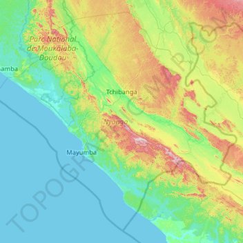
Name: Nyanga Province topographic map, elevation, terrain.
Location: Nyanga Province, Gabon (-4.10123 9.90740 -2.23836 11.97500)
Average elevation: 472 ft
Minimum elevation: 0 ft
Maximum elevation: 2,986 ft
Other topographic maps
Click on a map to view its topography, its elevation and its terrain.
Cap Lopez
Gabon > Ogooué-Maritime Province > Port-Gentil
Cap Lopez, Port-Gentil, Ogooué-Maritime Province, Gabon
Average elevation: 3 ft
Port-Gentil
Gabon > Ogooué-Maritime Province
Port-Gentil, Ogooué-Maritime Province, Gabon
Average elevation: 3 ft
Romboe
Gabon > Estuaire > Komo Department
Romboe, Komo Department, Estuaire, Gabon
Average elevation: 135 ft