
Make a donation
Gear up for your next adventure:
As an Amazon Associate, this site earns from qualifying purchases at no extra cost to you.
Tilff topographic map
Click on the map to display elevation.
Make a donation
Gear up for your next adventure:
As an Amazon Associate, this site earns from qualifying purchases at no extra cost to you.
Tilff
De rivier Ourthe loopt door het dorp van zuid naar noord. Aan de zuidzijde van Tilff liggen de Grotten van Sainte-Anne. De hoogte aan de Sint-Leodegariuskerk bedraagt 77 meter. De rotswanden herbergen nog diverse andere grotten.
Make a donation
Gear up for your next adventure:
As an Amazon Associate, this site earns from qualifying purchases at no extra cost to you.
About this map
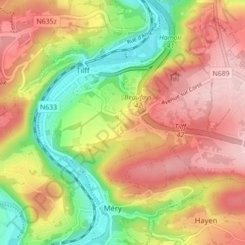
Name: Tilff topographic map, elevation, terrain.
Location: Tilff, Esneux, Luik, Wallonië, 4130, België (50.54200 5.56699 50.58106 5.61668)
Average elevation: 561 ft
Minimum elevation: 207 ft
Maximum elevation: 899 ft
Make a donation
Gear up for your next adventure:
As an Amazon Associate, this site earns from qualifying purchases at no extra cost to you.
Other topographic maps
Click on a map to view its topography, its elevation and its terrain.
Make a donation
Gear up for your next adventure:
As an Amazon Associate, this site earns from qualifying purchases at no extra cost to you.