Geolocate

中条山 topographic map

Interactive map

Click on the map to display elevation.

About this map

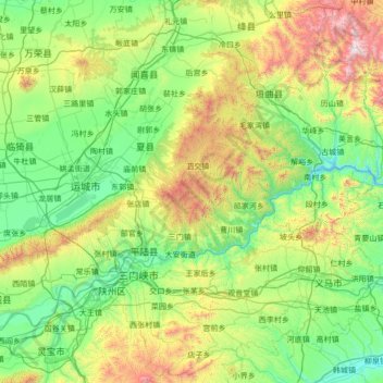
Name: 中条山 topographic map, elevation, terrain.

Location: 中条山, 平陆县, 运城市, 山西省, 044400, 中国 (34.73710 110.34256 35.27814 111.70349)

Average elevation: 2,195 ft

Minimum elevation: 676 ft

Maximum elevation: 7,552 ft

中条山,中国山西省南部主要山脉之一,位于黄河南向转东向的大弯处,东北-西南走向,东连太行山,南临黄河,西北为汾河谷地,西隔黄河与秦岭山区相望。因位于秦岭与太行之间,山势狭长而得名,全长约160公里。最高峰为海拔2358米的垣曲县历山舜王坪。

Wikipedia (CC-BY-SA 3.0)

Other topographic maps

Click on a map to view its topography, its elevation and its terrain.

龙源村

中国 > 山西省 > 平陆县

龙源村, 平陆县, 运城市, 山西省, 中国

Average elevation: 2,493 ft

常乐镇

中国 > 山西省 > 平陆县

常乐镇, 平陆县, 运城市, 山西省, 中国

Average elevation: 1,667 ft

西沟村

中国 > 山西省 > 平陆县

西沟村, 平陆县, 运城市, 山西省, 中国

Average elevation: 2,392 ft

后滩村

中国 > 山西省 > 平陆县 > 后滩村

后滩村, 平陆县, 运城市, 山西省, 中国

Average elevation: 2,428 ft

平陆县

中国 > 山西省 > 平陆县

平陆县, 运城市, 山西省, 中国

Average elevation: 2,037 ft

曹川镇

中国 > 山西省 > 平陆县 > 曹川镇

曹川镇, 平陆县, 运城市, 山西省, 中国

Average elevation: 1,798 ft

河南

中国 > 山西省 > 平陆县 > 下涧村 > 后沟

河南, 后沟, 下涧村, 平陆县, 运城市, 山西省, 中国

Average elevation: 2,096 ft