
Make a donation
Gear up for your next adventure:
As an Amazon Associate, this site earns from qualifying purchases at no extra cost to you.
Farlinville topographic map
Click on the map to display elevation.
Make a donation
Gear up for your next adventure:
As an Amazon Associate, this site earns from qualifying purchases at no extra cost to you.
About this map
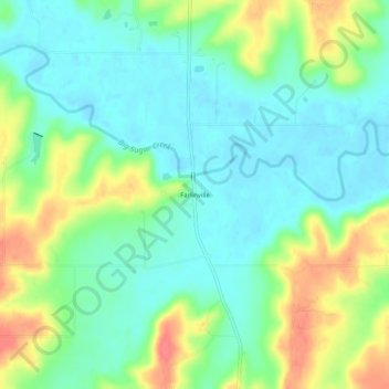
Name: Farlinville topographic map, elevation, terrain.
Location: Farlinville, Linn County, Kansas, United States (38.21336 -94.87385 38.25336 -94.83385)
Average elevation: 876 ft
Minimum elevation: 807 ft
Maximum elevation: 1,004 ft
Linn County trails, hiking, mountain biking, running and outdoor activities
Make a donation
Gear up for your next adventure:
As an Amazon Associate, this site earns from qualifying purchases at no extra cost to you.
Other topographic maps
Click on a map to view its topography, its elevation and its terrain.
Make a donation
Gear up for your next adventure:
As an Amazon Associate, this site earns from qualifying purchases at no extra cost to you.
Make a donation
Gear up for your next adventure:
As an Amazon Associate, this site earns from qualifying purchases at no extra cost to you.
Blue Mound
United States > Kansas > Linn County
Blue Mound was laid out in 1882. It was named by its first postmaster, John Q. Adams, because its elevation is said to look blue from a distance.
Average elevation: 1,056 ft