Geolocate

Phillips topographic map

Click on the map to display elevation.

About this map

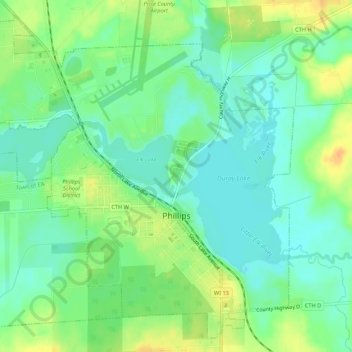
Name: Phillips topographic map, elevation, terrain.

Location: Phillips, Price County, Wisconsin, 54555, United States (45.67785 -90.43359 45.71243 -90.37982)

Average elevation: 1,463 ft

Minimum elevation: 1,421 ft

Maximum elevation: 1,526 ft

Price County trails, hiking, mountain biking, running and outdoor activities

Other topographic maps

Click on a map to view its topography, its elevation and its terrain.

Dover

United States > Wisconsin > Price County

Average elevation: 1,654 ft

Kennedy

United States > Wisconsin > Price County > Kennedy

Average elevation: 1,470 ft

Ogema

United States > Wisconsin > Price County

Average elevation: 1,565 ft

Worcester

United States > Wisconsin > Price County

Average elevation: 1,594 ft

Gear up for your next adventure:

🎒Day Hiking Backpack - Lightweight backpack perfect for day trips and outdoor adventures
🧷Carabiner Set - Durable clips for gear attachment
👓Polarized Sunglasses - Outdoor sunglasses for glare reduction
🎒Gear Packing Cubes - Organize your backpack efficiently
🥾Hiking Shoes - Durable and comfortable shoes for trail hiking

As an Amazon Associate, this site earns from qualifying purchases at no extra cost to you.