
Happy Valley topographic map
Click on the map to display elevation.
About this map
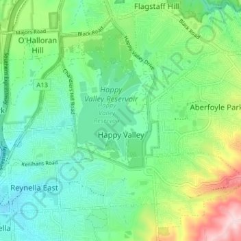
Name: Happy Valley topographic map, elevation, terrain.
Average elevation: 581 ft
Minimum elevation: 328 ft
Maximum elevation: 1,207 ft
Other topographic maps
Click on a map to view its topography, its elevation and its terrain.
Happy Valley Reservior
Australia > South Australia > City of Onkaparinga > Adelaide
Average elevation: 568 ft
Port Noarlunga Reef Sanctuary Zone
Australia > South Australia > City of Onkaparinga > Adelaide
Average elevation: 3 ft
Adelaide (Sellicks Hill) Weather Radar
Australia > South Australia > City of Onkaparinga > Adelaide
Average elevation: 955 ft