
Make a donation
Gear up for your next adventure:
As an Amazon Associate, this site earns from qualifying purchases at no extra cost to you.
Port Noarlunga Reef Sanctuary Zone topographic map
Click on the map to display elevation.
Make a donation
Gear up for your next adventure:
As an Amazon Associate, this site earns from qualifying purchases at no extra cost to you.
About this map
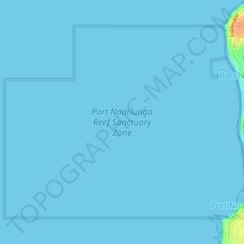
Name: Port Noarlunga Reef Sanctuary Zone topographic map, elevation, terrain.
Average elevation: 3 ft
Minimum elevation: 0 ft
Maximum elevation: 125 ft
Make a donation
Gear up for your next adventure:
As an Amazon Associate, this site earns from qualifying purchases at no extra cost to you.
Other topographic maps
Click on a map to view its topography, its elevation and its terrain.
Make a donation
Gear up for your next adventure:
As an Amazon Associate, this site earns from qualifying purchases at no extra cost to you.
Onkaparinga Hills
Australia > South Australia > City of Onkaparinga > Adelaide
Average elevation: 587 ft
Port Noarlunga South
Australia > South Australia > City of Onkaparinga > Adelaide
Average elevation: 30 ft
Cherry Gardens
Australia > South Australia > City of Onkaparinga > Adelaide
Average elevation: 1,102 ft
Make a donation
Gear up for your next adventure:
As an Amazon Associate, this site earns from qualifying purchases at no extra cost to you.
Huntfield Heights
Australia > South Australia > City of Onkaparinga > Adelaide
Average elevation: 203 ft
Make a donation
Gear up for your next adventure:
As an Amazon Associate, this site earns from qualifying purchases at no extra cost to you.
Cherry Gardens
Australia > South Australia > City of Onkaparinga > Adelaide
Average elevation: 1,102 ft
Make a donation
Gear up for your next adventure:
As an Amazon Associate, this site earns from qualifying purchases at no extra cost to you.
Make a donation
Gear up for your next adventure:
As an Amazon Associate, this site earns from qualifying purchases at no extra cost to you.
Make a donation
Gear up for your next adventure:
As an Amazon Associate, this site earns from qualifying purchases at no extra cost to you.
Noarlunga Downs
Australia > South Australia > City of Onkaparinga > Adelaide
Average elevation: 141 ft
Make a donation
Gear up for your next adventure:
As an Amazon Associate, this site earns from qualifying purchases at no extra cost to you.
Seaford Heights
Australia > South Australia > City of Onkaparinga > Adelaide
Average elevation: 200 ft
Onkaparinga Hills
Australia > South Australia > City of Onkaparinga > Adelaide
Average elevation: 587 ft
Aldinga Conservation Park
Australia > South Australia > City of Onkaparinga > Adelaide
Average elevation: 52 ft
Make a donation
Gear up for your next adventure:
As an Amazon Associate, this site earns from qualifying purchases at no extra cost to you.
Coromandel Valley
Australia > South Australia > City of Onkaparinga > Adelaide
Average elevation: 814 ft
Onkaparinga River National Park
Australia > South Australia > City of Onkaparinga > Adelaide
Average elevation: 456 ft
Make a donation
Gear up for your next adventure:
As an Amazon Associate, this site earns from qualifying purchases at no extra cost to you.
O'Sullivan Beach
Australia > South Australia > City of Onkaparinga > Adelaide
Average elevation: 98 ft
Make a donation
Gear up for your next adventure:
As an Amazon Associate, this site earns from qualifying purchases at no extra cost to you.
Huntfield Heights
Australia > South Australia > City of Onkaparinga > Adelaide
Average elevation: 203 ft
Make a donation
Gear up for your next adventure:
As an Amazon Associate, this site earns from qualifying purchases at no extra cost to you.
Adelaide (Sellicks Hill) Weather Radar
Australia > South Australia > City of Onkaparinga > Adelaide
Average elevation: 955 ft