
Red Lake topographic map
Click on the map to display elevation.
About this map
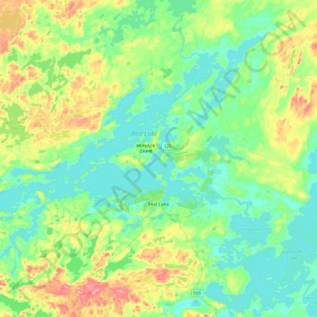
Name: Red Lake topographic map, elevation, terrain.
Average elevation: 1,253 ft
Minimum elevation: 1,155 ft
Maximum elevation: 1,512 ft
Other topographic maps
Click on a map to view its topography, its elevation and its terrain.
Slate Islands
Canada > Ontario > Kenora District > Unorganized Kenora District
Average elevation: 1,056 ft
Loveland Lake
Canada > Ontario > Kenora District > Unorganized Kenora District
Average elevation: 1,398 ft
Galbraith Lake
Canada > Ontario > Kenora District > Unorganized Kenora District
Average elevation: 1,493 ft
Edison Lake
Canada > Ontario > Kenora District > Unorganized Kenora District
Average elevation: 1,263 ft
Cole Lake
Canada > Ontario > Kenora District > Unorganized Kenora District
Average elevation: 1,368 ft
Banana Island
Canada > Ontario > Kenora District > Unorganized Kenora District
Average elevation: 1,178 ft
Ghost Island
Canada > Ontario > Kenora District > Unorganized Kenora District
Average elevation: 1,316 ft
Forbes Lake
Canada > Ontario > Kenora District > Sioux Narrows-Nestor Falls Township
Average elevation: 1,224 ft