
Sandy Lake topographic map
Click on the map to display elevation.
About this map
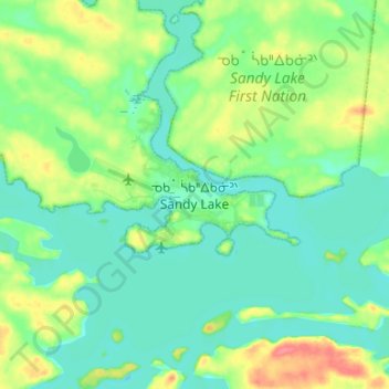
Name: Sandy Lake topographic map, elevation, terrain.
Average elevation: 932 ft
Minimum elevation: 873 ft
Maximum elevation: 1,076 ft
Other topographic maps
Click on a map to view its topography, its elevation and its terrain.
Lac Seul
Canada > Ontario > Kenora District
Lac Seul is a large, crescent shaped reservoir in Kenora District, northwestern Ontario, Canada. It is approximately 241 km (150 mi) long. It has a maximum (regulated) depth of 47.2 m, with a surface elevation of 357 m above sea level. Its level is raised in the summer and then drawn down in the winter months…
Average elevation: 1,273 ft
Gibi Lake
Canada > Ontario > Kenora District > Sioux Narrows-Nestor Falls Township
Average elevation: 1,224 ft
Nungesser Lake
Canada > Ontario > Kenora District > Unorganized Kenora District
Average elevation: 1,352 ft
Slate Islands
Canada > Ontario > Kenora District > Unorganized Kenora District
Average elevation: 1,056 ft
Loveland Lake
Canada > Ontario > Kenora District > Unorganized Kenora District
Average elevation: 1,398 ft
Galbraith Lake
Canada > Ontario > Kenora District > Unorganized Kenora District
Average elevation: 1,493 ft
Edison Lake
Canada > Ontario > Kenora District > Unorganized Kenora District
Average elevation: 1,263 ft
Sunlight Lake
Canada > Ontario > Kenora District > Unorganized Kenora District
Average elevation: 1,227 ft
Cole Lake
Canada > Ontario > Kenora District > Unorganized Kenora District
Average elevation: 1,368 ft
Banana Island
Canada > Ontario > Kenora District > Unorganized Kenora District
Average elevation: 1,178 ft
Ghost Island
Canada > Ontario > Kenora District > Unorganized Kenora District
Average elevation: 1,316 ft
Forbes Lake
Canada > Ontario > Kenora District > Sioux Narrows-Nestor Falls Township
Average elevation: 1,224 ft