
Gibsons topographic map
Click on the map to display elevation.
About this map
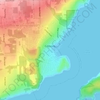
Name: Gibsons topographic map, elevation, terrain.
Average elevation: 187 ft
Minimum elevation: -3 ft
Maximum elevation: 541 ft
Other topographic maps
Click on a map to view its topography, its elevation and its terrain.
Roberts Creek
Canada > British Columbia > Sunshine Coast Regional District > Area D (Roberts Creek)
Average elevation: 184 ft
Secret Cove
Canada > British Columbia > Sunshine Coast Regional District > Area B (Halfmoon Bay)
Average elevation: 289 ft
Halfmoon Bay
Canada > British Columbia > Sunshine Coast Regional District > Area B (Halfmoon Bay)
Average elevation: 335 ft
Earls Cove
Canada > British Columbia > Sunshine Coast Regional District > Area A (Egmont/Pender Harbour)
Average elevation: 276 ft
Mount Helena
Canada > British Columbia > Sunshine Coast Regional District > Area A (Egmont/Pender Harbour)
Average elevation: 3,481 ft
Chapman Lake
Canada > British Columbia > Sunshine Coast Regional District > Area D (Roberts Creek)
Average elevation: 3,645 ft
Irvine Lake
Canada > British Columbia > Sunshine Coast Regional District > Area B (Halfmoon Bay)
Average elevation: 2,208 ft
Langdale
Canada > British Columbia > Sunshine Coast Regional District > Area F (West Howe Sound)
Average elevation: 180 ft
Pender Hill
Canada > British Columbia > Sunshine Coast Regional District > Area A (Egmont/Pender Harbour)
Average elevation: 157 ft
Mount Alice
Canada > British Columbia > Sunshine Coast Regional District > Area A (Egmont/Pender Harbour)
Average elevation: 4,147 ft
Mount Albert
Canada > British Columbia > Sunshine Coast Regional District > Area A (Egmont/Pender Harbour)
Average elevation: 6,355 ft
Mount Churchill
Canada > British Columbia > Sunshine Coast Regional District > Area A (Egmont/Pender Harbour)
Average elevation: 3,773 ft
South
Canada > British Columbia > Sunshine Coast Regional District > Area B (Halfmoon Bay)
Average elevation: 30 ft
Mount Artaban
Canada > British Columbia > Sunshine Coast Regional District > Area F (West Howe Sound)
Average elevation: 581 ft
Macdonald Island
Canada > British Columbia > Sunshine Coast Regional District > Area A (Egmont/Pender Harbour)
Average elevation: 755 ft
Highest Peak
Canada > British Columbia > Sunshine Coast Regional District > Area F (West Howe Sound) > Plumper Cove
Average elevation: 138 ft
Mount Helena
Canada > British Columbia > Sunshine Coast Regional District > Area A (Egmont/Pender Harbour)
Average elevation: 3,481 ft
Gower Point
Canada > British Columbia > Sunshine Coast Regional District > Area E (Elphinstone)
Average elevation: 108 ft
Langdale
Canada > British Columbia > Sunshine Coast Regional District > Area F (West Howe Sound)
Average elevation: 180 ft