
Make a donation
Gear up for your next adventure:
As an Amazon Associate, this site earns from qualifying purchases at no extra cost to you.
Montalvo topographic map
Click on the map to display elevation.
Make a donation
Gear up for your next adventure:
As an Amazon Associate, this site earns from qualifying purchases at no extra cost to you.
About this map
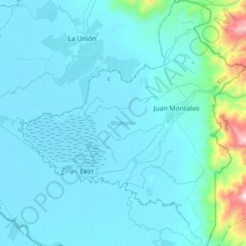
Name: Montalvo topographic map, elevation, terrain.
Location: Montalvo, Los Ríos, 120111, Ecuador (-1.93871 -79.46409 -1.66627 -79.21090)
Average elevation: 482 ft
Minimum elevation: 7 ft
Maximum elevation: 5,712 ft
Make a donation
Gear up for your next adventure:
As an Amazon Associate, this site earns from qualifying purchases at no extra cost to you.
Other topographic maps
Click on a map to view its topography, its elevation and its terrain.
San Jacinto de Buena Fe
Ecuador > Los Ríos > Buena Fe > San Jacinto de Buena Fe
Average elevation: 292 ft
Make a donation
Gear up for your next adventure:
As an Amazon Associate, this site earns from qualifying purchases at no extra cost to you.