
Bolinas topographic map
Click on the map to display elevation.
Bolinas
Bolinas sits at an elevation of 36 feet (11 m) above sea level. It is bound on the northeast by Bolinas Lagoon and Kent Island, on the south by Bolinas Bay and Duxbury Point, on the southwest by the Pacific Ocean, and on the northwest by Point Reyes National Seashore. According to the United States Census Bureau, the CDP has a total area of 5.8 square miles (15 km2), all of it land. The GNIS has cited archaic alternate town-names, including "Ballenas", "Baulenas", "Baulings", and "Bawlines".
About this map
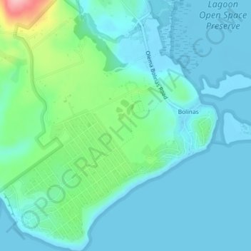
Name: Bolinas topographic map, elevation, terrain.
Location: Bolinas, Marin County, California, United States (37.89391 -122.71636 37.92177 -122.68199)
Average elevation: 92 ft
Minimum elevation: -3 ft
Maximum elevation: 489 ft
Marin County trails, hiking, mountain biking, running and outdoor activities
Other topographic maps
Click on a map to view its topography, its elevation and its terrain.
San Anselmo
United States > California > Marin County
San Anselmo (Spanish for "Saint Anselm") is an incorporated town in Marin County, California, United States. San Anselmo is located 1.5 miles (2.4 km) west of San Rafael, at an elevation of 46 feet (14 m). It is located about 20 miles (32 km) north of San Francisco. The town is bordered by San Rafael to the…
Average elevation: 217 ft
San Rafael
United States > California > Marin County
San Rafael has a wide diversity of natural habitats from forests at the higher elevations to marshland and estuarine settings. Its marshes are home to the endangered species salt marsh harvest mouse. There are also riparian areas including the San Rafael Creek and Miller Creek corridors.
Average elevation: 256 ft
Kentfield
United States > California > Marin County > Kentfield
Kentfield (formerly Ross Landing, Tamalpais, and Kent) is a census-designated place (CDP) in Marin County, California, United States, just north of San Francisco. Kentfield is located 2 miles (3 km) southwest of downtown San Rafael, at an elevation of 115 feet (35 m). The population was 6,808 at the 2020…
Average elevation: 495 ft
Larkspur
United States > California > Marin County
Larkspur is a city in Marin County, California, United States. Larkspur is located 3 miles (4.8 km) south of San Rafael, at an elevation of 43 feet (13 m). As of the 2020 Census, the city's population was 13,064. Larkspur's Police Department is shared with that of the neighboring Corte Madera and town of San…
Average elevation: 174 ft
Old Saint Hilary's Open Space Preserve
United States > California > Marin County > Tiburon > Hill Haven
Average elevation: 138 ft
Nicasio
United States > California > Marin County
Nicasio (/nɪˈkɑːsi.oʊ/ nih-KAH-see-oh; Spanish for "Nicasius") is an unincorporated community and census-designated place in Marin County, California, United States. It is located 8 miles (13 km) west-southwest of Novato, at an elevation of 194 feet (59 m). As of the 2020 census the CDP population was 81,…
Average elevation: 400 ft
Stinson Beach
United States > California > Marin County > Stinson Beach
Stinson Beach is an unincorporated community and census-designated place (CDP) in Marin County, California, on the west coast of the United States. Stinson Beach is located east-southeast of Bolinas, right across the channel that terminates the bay mouth bar of the Bolinas Lagoon. at an elevation of 26 feet (8…
Average elevation: 489 ft
Fairfax
United States > California > Marin County
Fairfax is an incorporated town in Marin County, California, United States. Fairfax is located 3.25 miles (5.2 km) west-northwest of San Rafael, at an elevation of 115 feet (35 m). The population was 7,605 at the 2020 census.
Average elevation: 318 ft
Dillon Beach
United States > California > Marin County
Dillon Beach is a census-designated place (CDP) in Marin County, California, United States. It is located 3.25 miles (5.2 km) west of Tomales, at an elevation of 89 ft (27 m). The population was 246 at the 2020 census. Dillon Beach was named after the founder, George Dillon, who settled there in 1858. The area…
Average elevation: 184 ft
Ross
United States > California > Marin County
Ross is a small incorporated town in Marin County, California, United States, just north of San Francisco. Ross is located 1.5 miles (2.4 km) west-southwest of San Rafael, at an elevation of 36 feet (11 m). The population was 2,338 at the 2020 census. The town is bordered by San Rafael to the east, Kentfield…
Average elevation: 161 ft
Point Reyes Station
United States > California > Marin County
Point Reyes Station (formerly Marin and Olema Station) is a small unincorporated town in western Marin County, California, United States. Point Reyes Station is located 13 miles (21 km) south-southeast of Tomales, at an elevation of 39 feet (12 m). Point Reyes Station is located along State Route 1 and is a…
Average elevation: 217 ft
Bel Marin Keys
United States > California > Marin County
Bel Marin Keys is an unincorporated community in Marin County, California. It lies at an elevation of 10 feet (3.0 m).
Average elevation: 13 ft
San Rafael
United States > California > Marin County
San Rafael has a wide diversity of natural habitats from forests at the higher elevations to marshland and estuarine settings. Its marshes are home to the endangered species salt marsh harvest mouse. There are also riparian areas including the San Rafael Creek and Miller Creek corridors.
Average elevation: 256 ft
San Anselmo
United States > California > Marin County
San Anselmo (Spanish for 'Saint Anselm') is an incorporated town in Marin County, California, United States. San Anselmo is located 1.5 miles (2.4 km) west of San Rafael, at an elevation of 46 feet (14 m). It is located about 20 miles (32 km) north of San Francisco. The town is bordered by San Rafael to the…
Average elevation: 217 ft
Corte Madera
United States > California > Marin County
Corte Madera (/ˈkɔːrtə məˈdɛrə/; Spanish for "Chop Wood") is an incorporated town in Marin County, California, United States. Corte Madera is located 3.25 miles (5.2 km) south of San Rafael, at an elevation of 39 feet (12 m). The population was 9,838 at the 2019 census. The town was named after the…
Average elevation: 171 ft
Fairfax
United States > California > Marin County
Fairfax is an incorporated town in Marin County, California, United States. Fairfax is located 3.25 miles (5.2 km) west-northwest of San Rafael, at an elevation of 115 feet (35 m). The population was 7,605 at the 2020 census.
Average elevation: 318 ft
San Rafael
United States > California > Marin County
San Rafael has a wide diversity of natural habitats from forests at the higher elevations to marshland and estuarine settings. Its marshes are home to the endangered species salt marsh harvest mouse. There are also riparian areas including the San Rafael Creek and Miller Creek corridors.
Average elevation: 259 ft
Point Reyes
United States > California > Marin County
Point Reyes is bounded to the east by the San Andreas Fault, which runs directly under Tomales Bay, and is structurally dominated by the Point Reyes Syncline. The Point Reyes Peninsula is on the Pacific Plate, while the rest of Marin County land is on the North American Plate. The peninsula is a member of the…
Average elevation: 33 ft
San Rafael
United States > California > Marin County
San Rafael has a wide diversity of natural habitats from forests at the higher elevations to marshland and estuarine settings. Its marshes are home to the endangered species salt marsh harvest mouse. There are also riparian areas including the San Rafael Creek and Miller Creek corridors.
Average elevation: 259 ft
Ross
United States > California > Marin County
Ross is a small incorporated town in Marin County, California, United States, just north of San Francisco. Ross is located 1.5 miles (2.4 km) west-southwest of San Rafael, at an elevation of 36 feet (11 m). The population was 2,338 at the 2020 census. The town is bordered by San Rafael to the east, Kentfield…
Average elevation: 161 ft
San Rafael
United States > California > Marin County
San Rafael has a wide diversity of natural habitats from forests at the higher elevations to marshland and estuarine settings. Its marshes are home to the endangered species salt marsh harvest mouse. There are also riparian areas including the San Rafael Creek and Miller Creek corridors.
Average elevation: 259 ft
Corte Madera
United States > California > Marin County
Corte Madera (/ˈkɔːrtə məˈdɛrə/; Spanish for "Chop Wood") is an incorporated town in Marin County, California. Corte Madera is located 3.25 miles (5.2 km) south of San Rafael, at an elevation of 39 feet (12 m). The population was 10,222 at the 2020 census. The town was named after the Spanish…
Average elevation: 171 ft
Fairfax
United States > California > Marin County
Fairfax is an incorporated town in Marin County, California, United States. Fairfax is located 3.25 miles (5.2 km) west-northwest of San Rafael, at an elevation of 115 feet (35 m). The population was 7,605 at the 2020 census.
Average elevation: 318 ft
Larkspur
United States > California > Marin County
Larkspur is a city in Marin County, California, United States. Larkspur is located 3 miles (4.8 km) south of San Rafael, at an elevation of 43 feet (13 m). As of the 2020 Census, the city's population was 13,064. Larkspur's Police Department is shared with that of the neighboring Corte Madera and town of San…
Average elevation: 174 ft
Baltimore Park
United States > California > Marin County > Larkspur > Baltimore Park
Average elevation: 190 ft