Geolocate

Lula topographic map

Click on the map to display elevation.

About this map

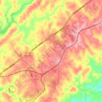
Name: Lula topographic map, elevation, terrain.

Location: Lula, Hall County, Georgia, 30554, United States (34.36506 -83.70026 34.43547 -83.64070)

Average elevation: 1,211 ft

Minimum elevation: 922 ft

Maximum elevation: 1,371 ft

Hall County trails, hiking, mountain biking, running and outdoor activities

Other topographic maps

Click on a map to view its topography, its elevation and its terrain.

Murrayville

United States > Georgia > Hall County

Average elevation: 1,207 ft

Deaton Creek

United States > Georgia > Hall County

Average elevation: 909 ft

Briarwood

United States > Georgia > Hall County > Oakwood

Average elevation: 1,201 ft

Chestatee North

United States > Georgia > Hall County

Average elevation: 1,158 ft

Timberidge

United States > Georgia > Hall County

Average elevation: 1,148 ft

Frontier Trail

United States > Georgia > Hall County

Average elevation: 1,043 ft

Lake Ranch

United States > Georgia > Hall County

Average elevation: 1,155 ft

Strickland Heights

United States > Georgia > Hall County

Average elevation: 1,066 ft

Georgia Island

United States > Georgia > Hall County

Average elevation: 1,089 ft

Green Crossing

United States > Georgia > Hall County > Buford

Average elevation: 1,161 ft

Colony South

United States > Georgia > Hall County

Average elevation: 1,076 ft

Johnson

United States > Georgia > Hall County

Average elevation: 1,119 ft

Scoutland

United States > Georgia > Hall County > Scoutland

Average elevation: 1,125 ft

Gear up for your next adventure:

🪶Survival Guide Book - Expert advice for emergency preparedness
🕶️Glacier Sunglasses - Side shields to protect eyes from high-altitude snow glare
🧭Outdoor Navigation Book - Learn advanced navigation skills
🦺Reflective Outdoor Gear - Safety gear for low‑light conditions
🩹Survival Bandages - High‑quality bandages for emergencies

As an Amazon Associate, this site earns from qualifying purchases at no extra cost to you.