Geolocate

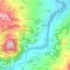
Ferriere topographic map

Click on the map to display elevation.

About this map
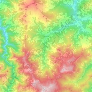
Name: Ferriere topographic map, elevation, terrain.

Location: Ferriere, Piacenza, Emilia-Romagna, 29024, Italy (44.55588 9.38503 44.70072 9.60321)

Average elevation: 3,228 ft

Minimum elevation: 1,217 ft

Maximum elevation: 5,837 ft

Other topographic maps

Click on a map to view its topography, its elevation and its terrain.

Pianazze

Italy > Emilia-Romagna > Piacenza > Vernasca

Average elevation: 1,138 ft

Ramara

Italy > Emilia-Romagna > Piacenza > Cadeo

Average elevation: 187 ft

Fiorano

Italy > Emilia-Romagna > Piacenza > Travo

Average elevation: 932 ft

Dadomo

Italy > Emilia-Romagna > Piacenza > Vernasca

Average elevation: 2,264 ft

Crocinito

Italy > Emilia-Romagna > Piacenza

Average elevation: 1,854 ft

Bogli

Italy > Emilia-Romagna > Piacenza > Ottone

Average elevation: 3,898 ft

Misano

Italy > Emilia-Romagna > Piacenza > Agazzano

Average elevation: 787 ft

Sariano

Italy > Emilia-Romagna > Piacenza > Gropparello

Average elevation: 873 ft

Capannette di Pej

Italy > Emilia-Romagna > Piacenza > Zerba

Average elevation: 4,304 ft

Gear up for your next adventure:

🪶Compact Camp Shovel - Folding shovel for campsite tasks
🧭Compass with Lanyard - Easy‑carry compass for navigation
🦟Ultrasonic Repellers - Create a bug-free zone at your camp or rest stop
🔦LED Headlamp - Bright and durable LED headlamp for night navigation
🪶Survival Guide Book - Expert advice for emergency preparedness

As an Amazon Associate, this site earns from qualifying purchases at no extra cost to you.