
Bolton topographic map
Click on the map to display elevation.
About this map
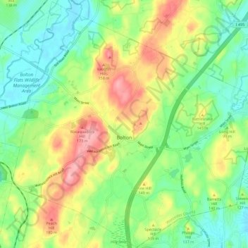
Name: Bolton topographic map, elevation, terrain.
Average elevation: 377 ft
Minimum elevation: 207 ft
Maximum elevation: 650 ft
Worcester County trails, hiking, mountain biking, running and outdoor activities
Other topographic maps
Click on a map to view its topography, its elevation and its terrain.
Gates Crossing
United States > Massachusetts > Worcester County > Leominster
Average elevation: 407 ft
Wachusett Station
United States > Massachusetts > Worcester County > Fitchburg
Average elevation: 751 ft
Central (Stanley) Woolen Mill District Park
United States > Massachusetts > Worcester County > Uxbridge
Average elevation: 262 ft
Crow Hill Ledges
United States > Massachusetts > Worcester County > Westminster
Average elevation: 961 ft
Olde English Village
United States > Massachusetts > Worcester County > Gardner
Average elevation: 1,010 ft
Vernon Hill
United States > Massachusetts > Worcester County > Worcester > Quinsigamond Village
Average elevation: 531 ft
Royalston Falls
United States > Massachusetts > Worcester County > Royalston
Average elevation: 994 ft
South Charlton Reservoir
United States > Massachusetts > Worcester County > Charlton > South Charlton
Average elevation: 666 ft
Tatnuck
United States > Massachusetts > Worcester County > Worcester > Tatnuck Square
Average elevation: 725 ft
Blackburn Village
United States > Massachusetts > Worcester County > Ashburnham
Average elevation: 1,070 ft
Bassets Corner
United States > Massachusetts > Worcester County > Petersham
Average elevation: 1,063 ft
Hadwen Park
United States > Massachusetts > Worcester County > Worcester > Heard Street
Average elevation: 545 ft
Institute Park
United States > Massachusetts > Worcester County > Worcester > Belmont Hill
Average elevation: 558 ft
Thompsons Pond Dam
United States > Massachusetts > Worcester County > Spencer
Average elevation: 912 ft
Phillipston Four Corners
United States > Massachusetts > Worcester County > Phillipston
Average elevation: 1,099 ft
South Royalston
United States > Massachusetts > Worcester County > Royalston
Average elevation: 942 ft
Northbridge Center
United States > Massachusetts > Worcester County > Northbridge
Average elevation: 407 ft
Plummers Hill
United States > Massachusetts > Worcester County > Northbridge
Average elevation: 335 ft
West Upton
United States > Massachusetts > Worcester County > Upton > West Upton
Average elevation: 364 ft
Jefferson
United States > Massachusetts > Worcester County > Holden > Jefferson
Average elevation: 814 ft
Hammond Heights
United States > Massachusetts > Worcester County > Worcester
Average elevation: 568 ft
Summit
United States > Massachusetts > Worcester County > Worcester > Summit
Average elevation: 653 ft
North Worcester
United States > Massachusetts > Worcester County > Worcester
Average elevation: 709 ft