Geolocate

Dundee topographic map

Click on the map to display elevation.

About this map

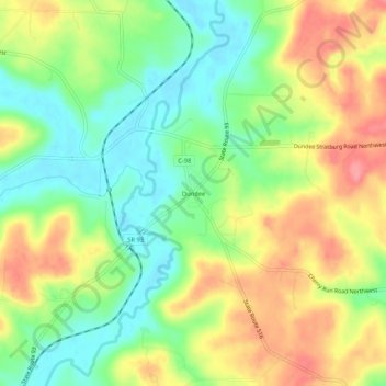
Name: Dundee topographic map, elevation, terrain.

Location: Dundee, Tuscarawas County, Ohio, 44624, United States (40.56673 -81.62818 40.60673 -81.58818)

Average elevation: 1,076 ft

Minimum elevation: 948 ft

Maximum elevation: 1,224 ft

Tuscarawas County trails, hiking, mountain biking, running and outdoor activities

Other topographic maps

Click on a map to view its topography, its elevation and its terrain.

Baltic

United States > Ohio > Tuscarawas County

Average elevation: 1,096 ft

Zoar

United States > Ohio > Tuscarawas County

Average elevation: 948 ft

Strasburg

United States > Ohio > Tuscarawas County

Average elevation: 978 ft

Bolivar

United States > Ohio > Tuscarawas County

Average elevation: 935 ft

Uhrichsville

United States > Ohio > Tuscarawas County

Average elevation: 919 ft

Newcomerstown

United States > Ohio > Tuscarawas County

Average elevation: 886 ft

Roswell

United States > Ohio > Tuscarawas County > Roswell

Average elevation: 1,060 ft

Mineral City

United States > Ohio > Tuscarawas County

Average elevation: 1,024 ft

Gear up for your next adventure:

📚Navigation Handbooks - Master the art of reading topographic maps and using a compass
📡GPS Antenna Upgrade - Enhance GPS reception in remote terrain
😴Insulated Sleeping Pads - Compact and warm pads for high-elevation camping
🕶️Glacier Sunglasses - Side shields to protect eyes from high-altitude snow glare
📻Weather Alert Radios - Stay informed of storm risks while off-the-grid

As an Amazon Associate, this site earns from qualifying purchases at no extra cost to you.