Geolocate

Bolivar topographic map

Click on the map to display elevation.

About this map

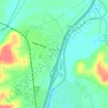
Name: Bolivar topographic map, elevation, terrain.

Location: Bolivar, Tuscarawas County, Ohio, United States (40.63914 -81.46178 40.65873 -81.44770)

Average elevation: 935 ft

Minimum elevation: 869 ft

Maximum elevation: 1,079 ft

Tuscarawas County trails, hiking, mountain biking, running and outdoor activities

Other topographic maps

Click on a map to view its topography, its elevation and its terrain.

Willow Glen

United States > Ohio > Tuscarawas County > Dover

Average elevation: 922 ft

Dundee

United States > Ohio > Tuscarawas County

Average elevation: 1,076 ft

Columbia

United States > Ohio > Tuscarawas County

Average elevation: 1,020 ft

Sandyville

United States > Ohio > Tuscarawas County

Average elevation: 981 ft

Peoli

United States > Ohio > Tuscarawas County

Average elevation: 1,079 ft

Gilmore

United States > Ohio > Tuscarawas County

Average elevation: 1,119 ft

Gear up for your next adventure:

📖Nature Tracking Books - Learn to track wildlife and terrain
📡GPS Antenna Upgrade - Enhance GPS reception in remote terrain
🔥Camping Stove - Portable stove for camping and backcountry cooking
🌡️Handheld Weather Meters - Measure wind, temp, and pressure for safe mountain travel
🥄Camping Utensil Set - Lightweight utensils for outdoor meals

As an Amazon Associate, this site earns from qualifying purchases at no extra cost to you.