Geolocate

Baltic topographic map

Click on the map to display elevation.

About this map

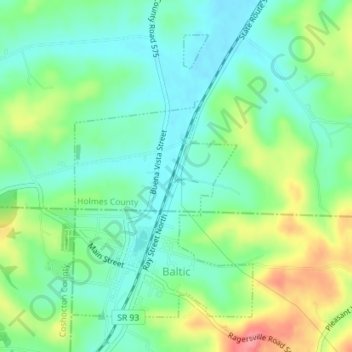
Name: Baltic topographic map, elevation, terrain.

Location: Baltic, Tuscarawas County, Ohio, United States (40.43655 -81.71026 40.45826 -81.69129)

Average elevation: 1,096 ft

Minimum elevation: 997 ft

Maximum elevation: 1,296 ft

Tuscarawas County trails, hiking, mountain biking, running and outdoor activities

Other topographic maps

Click on a map to view its topography, its elevation and its terrain.

Dundee

United States > Ohio > Tuscarawas County

Average elevation: 1,076 ft

Columbia

United States > Ohio > Tuscarawas County

Average elevation: 1,020 ft

Sandyville

United States > Ohio > Tuscarawas County

Average elevation: 981 ft

Willow Glen

United States > Ohio > Tuscarawas County > Dover

Average elevation: 922 ft

Peoli

United States > Ohio > Tuscarawas County

Average elevation: 1,079 ft

Gilmore

United States > Ohio > Tuscarawas County

Average elevation: 1,119 ft

Gear up for your next adventure:

🪑Ultralight Camp Chairs - Portable seating for resting after a long day of mapping
🥤Water Filter Bottle - All‑in‑one filter bottle for safe hydration
🌲Outdoor Survival Books - Best books on survival skills
🔌Solar Panel Charger - Charge gear sustainably outdoors
🧤Tactile Hiking Gloves - Keep hands warm while operating GPS and smartphone screens

As an Amazon Associate, this site earns from qualifying purchases at no extra cost to you.