Geolocate

Ariel topographic map

Click on the map to display elevation.

About this map

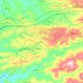
Name: Ariel topographic map, elevation, terrain.

Location: Ariel, Area C, Judea and Samaria, Palestinian Territory (32.07441 35.11244 32.11075 35.21894)

Average elevation: 1,660 ft

Minimum elevation: 938 ft

Maximum elevation: 2,628 ft

Other topographic maps

Click on a map to view its topography, its elevation and its terrain.

Barkan

Palestinian Territory > Judea and Samaria > Area C

Average elevation: 1,342 ft

Yitzhar

Palestinian Territory > Judea and Samaria > Area C

Average elevation: 2,093 ft

Alon Shvut

Palestinian Territory > Judea and Samaria > Area C

Average elevation: 3,022 ft

Meitzad

Palestinian Territory > Judea and Samaria > Area C

Average elevation: 2,838 ft

Gitit

Palestinian Territory > Judea and Samaria > Area C

Average elevation: 823 ft

Rimonim

Palestinian Territory > Judea and Samaria > Area C

Average elevation: 1,942 ft

Bat Ayin

Palestinian Territory > Judea and Samaria > Area C

Average elevation: 2,671 ft

Hermesh

Palestinian Territory > Judea and Samaria > Area C

Average elevation: 682 ft

HaRoeh

Palestinian Territory > Judea and Samaria > Area C > Eli

Average elevation: 2,228 ft

Keidar

Palestinian Territory > Judea and Samaria > Area C

Average elevation: 1,394 ft

Gear up for your next adventure:

🔭Compact Binoculars - HD vision for scouting terrain and identifying distant landmarks
🧤Hiking Gloves - Protective gloves for rugged trails
🔥Plasma Lighters - Windproof lighters that work in any weather condition
🔦LED Headlamp - Bright and durable LED headlamp for night navigation
🛠️Outdoor Gear Repair Kit - Essential tools to fix gear on the trail

As an Amazon Associate, this site earns from qualifying purchases at no extra cost to you.